Tuesday, July 30, 2013

Alaska Big Wild Ride 1200 km

July 2013
Ride Report
Worthington Glacier on the road to Valdez

The Sell

I was thinking about trying to get a 1200km ride on the calendar this year, and the easiest way to make that happen is to work it around a vacation 'a la PBP.' Just before mass one morning I am cruising the RUSA website and see the logo for the Alaska Big Wild Ride (BWR). Deb and I have been wanting to visit Alaska for years, here was my chance! While Deb was warming up with the band at church (she plays the flute) before the procession, I say, "what do you think about going to Alaska for a cruise?" She says, "why is there a bike race involved?" Saved by the bells, and mass starting, I could only grin and return to my pew and pray! 

We couldn't work out a cruise, but we did the next best thing. We rented a RV in Anchorage and toured the Kenai Peninsula and Valdez for the week prior to the event. We had a blast, a full photo report is here. Generally; we took glacier cruises out of Seward and Valdez, visited the Alaska Sea Life Center (Seward), Pratt Museum (Homer), Anchorage Museum, Alyeska Tram, Kenai, Whittier, and the Matanuska Glacier!

We had an awesome time, and by the time the BWR was ready to start, Deb was an expert at slinging the 31 foot RV around like it was a Mini Cooper!

Check-in and rider meeting

Our RV park in Valdez had cable, so after catching the final stage of the Tour de France and attending a mass at the local Catholic parish, I was able to meet Kevin Turinsky get my bike checked and pick up copies of the final cue sheets. Then it was back to the RV to see if Chris Fromme still won the tour during the stage re-run, and to try and catch some sleep before the 11 pm rider meeting.
Kevin Turinsky - Alaska RBA and BWR Trail Boss
Kevin Turinsky, Alaska RUSA Regional Brevet Administrator and Trail Boss for this event provided the 45 riders that would line up for the BWR with a schedule of events for the next 90 hours. He outlined the procedures to be followed at the controls and described the areas where we were likely to encounter construction. We became very familiar with road construction on our RV tour in the week before encountering many sections of road under various stages of repair. We would encounter many more during the BWR.

The meeting wrapped up and we milled around parking lot swatting mosquitoes and enjoying some blues/rock from a local trio that added to the festive nature of the start. Lots of photos were taken, most were overpowered by the reflective gear we were all wearing! The race photographer pointed the headlights of two vehicles at us and voila, great shots!
In the glare of a pickup's headlights at the start line

Start and Day 1

We rolled out at midnight as a single group, and the bunch slowly picked up the pace on the 15 or so miles of the pancake flat run toward the start of the 15 mile climb to Thompson Pass. There was no significant wind and we were clipping along at 20 miles an hour at an easy pace. It was fun to see Debby swing the RV into the passing lane and overtake the bunch on her way to control at Tonsina Lodge. She would get there in 90 minutes or so, and sleep there until I would arrive between 6 and 7 am.

I thought, nice we will all get the base of the first climb at no effort at all. Then I notice, that mushy, bouncy feeling you get just before the rear wheel flats out. D'oh! Flat! I pull out of the pace line and pull off. I get the tube changed quickly, find and remove the fragment of steel cable that caused my delay, but the freight train is well down the tracks. I figured I won't see another tail light until the climbing starts and didn't.

On the climb I caught a few riders but as I crested the top, I was blasted with a cold wet wind out of the north. I stopped to put on my layers and rain jacket. It was a cold wet descent to the control at Tsaina Lodge (38 miles). I reloaded my bottles with Hammer SE and a Coke and was on my way. While there was no rain the in the forecast, I remembered the admonition the Bob Marshall Wilderness Forest Ranger gave my hiking buddy Bill Boyle; "Don't you boys be fooled by the going in weather!" My rain pants were up the road waiting at the next control!

The rain eased off on the run to the next control but the north wind continued to build. I rolled into the control at Tonsina River Lodge (82 miles) at about 0600 cold and wet. I grabbed a hot coffee in the lodge and had Deb warm up a can of beans in the RV. I was back on the road in 20 minutes. Deb packed up the RV and headed up to the Control at the Sourdough Roadhouse so she could take another long nap. There were several great views of the Trans-Alaska Pipeline in this section. Its route generally paralleled highway we were following all the way to Fairbanks.

Trans-Alaska Pipe line

The road gently climbed and the rain did not reappear, but the wind continued to build to the next control at the Hub of Alaska in Glennallen (119 miles). There were a big  bunch of riders there. I grabbed a Frappachino, reloaded my bottles at the Tesoro convenience store and was out of there in about 10 minutes. About an hour later a big train of riders came by and I jumped in. It was nice to have some relief from the wind and we worked well together.

This section introduced us to the 'loose gravel' sections we would encounter often on the highway. Sections 50-300 meters long of what at first looks like chip seal, but was made up of much larger stones (large marble sized) glued to the surface with tar. In any case it really disrupted our pace and was extremely uncomfortable to ride on, I affectionately referred to it as Alaska Chip Seal!

Mosquito incubator and 'Alaska Chip Seal' section
We rolled into the Sourdough roadhouse (154 miles) about 1215 and were held up by the race organizers while they determined road construction conditions up the road, which was OK since it was lunch time. Deb fired up some soup. The mosquitoes were so bad here, and like most stops, Deb refused to leave the shelter of the camper. Any unfortunate pest that found its way into the camper would find itself at the receiving end of Deb's fly swatter. Yes they were big enough to require the full sized swatter, and as the event progressed, many carcases littered the RV!  After 45 minutes the volunteers determined it was good to go so I rolled out alone, most of the bunch was still enjoying their lunch in the road house.
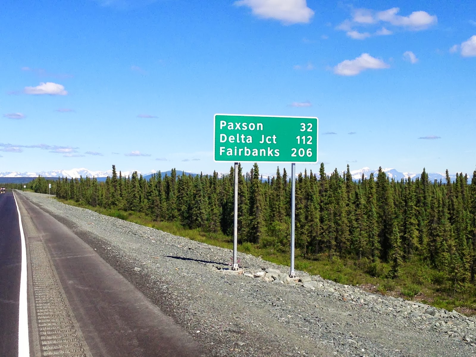
New road section before the construction, Delta Jct is the first sleep stop
After a few more sections of Alaska Chip Seal we were treated to 15-20 miles of fresh pavement before we hit the patch of road the organizers were concerned about. There were deep potholes, but in the daylight they were easy to avoid, and more importantly, easier to ride than the Alaska Chip Seal sections! I rolled into the control at Paxson lodge (189 miles) about 1400 and took a 20 minute break before pressing on.

Summit Lake
The road continued to climb to Summit Lake with great mountain views. The wind was still strong out of the north, and was quite chilly blowing off the surface of the cold lake. The race photographers set up a spot for taking photographs and I took a short break here, thinking that most of the climbing for the day was over and the next sections were generally downhill.
Near Summit Lake
The winds were actually stronger on the downhill side, so it was just as hard work going down as it was going up. I was joined by another rider who's rear shifter failed, so he had only two gears to work with and could only pull occasionally as we fought through the wind. The next control was the Lodge at Black Rapids (231 miles). The lodge actually sits atop a small bluff with a very steep dirt driveway. It was so steep, Deb could not get the RV up the driveway. It reminded me of the steep driveway at the Elgin Community center on the Tombstone 600, only steeper! I checked in and rolled back down the driveway to grab a light dinner in the RV. I leaned my bike against the camper and went inside.

A few minutes later a Cessna 172 rolls out of the garage and starts spooling up for take off just in front of the camper on a short gravel landing strip (Apparently the shoulder doubles as a landing strip!). As the pebbles began to pelt the RV before he took off, I suggested to Deb that we should move the camper back. I run to the back window to make sure its clear and Deb starts to back up, then we hear a bump -- Oh crap, my bike! It was leaning against the RV. Luckily it was not damaged, but it was only inches from the front wheel! The Cessna took off and we were both relieved the bike was OK. I must admit however, that at that point in the ride, if the bike had been ruined, I would have been happy to stop the ride right there!

Back on the bike after a light dinner and only 231 miles into the ride I was feeling the effects of 20 hours of riding, most of it unprotected into the wind. I still had 3 hours of riding to the sleep control. The course leaves the river and climbs 700 feet to a tundra area before it levels off and heads to Delta Junction.
Roadside pullout at the pipeline
The sun was finally starting to set at 2000 and I was wet from perspiration on the climb. I stopped at the top to put on arm, leg warmers, and my reflective vest when Chip and Clint from the DC Randonneurs flashed by. I hopped on the bike and managed to catch them. We worked together on the last 17 miles to Delta at a good pace that helped the miles go by. Also we saw quite a few Moose and other wildlife on the high tundra. We reached an Army base outside of town that seemed to go on forever, but we finally found the sleep stop at about 2300. I checked in and returned to the RV for a shower and dinner. I crawled into the sack at about midnight and set the alarm for 0400.

Day 1: 270 miles; 11,000 feet of climbing; 23 hours

Day 2

Deb set her iPad alarm as a backup, however it was still on AZ time, so I rolled out of bed and started to get dressed, and then noticed it was 0300 not 0400; so I crawled back into bed for another hour. It seemed like my head hit the pillow just as the 0400 alarm went off. So with a light breakfast of pasta and coffee, I was back on the road at 0455 (control closing time). Deb moved the RV up to the next control at Midway Lodge.

This next section was the low point of the ride for me. I had not recovered from Day 1 and could not generate much power on the rollers. I would get sweaty on the uphills and chilled on the downhills. Three guys from the Pennsylvania Randonnuers flashed by and I was only able to hold their wheels until the next steep uphill. Halfway to the control I was toast. Deb encouraged me on and I finally made the control at Midway Lodge (317 miles). We decided to take a long breakfast break and Deb cooked up some bacon and egg burritos. I also took a 45 minute nap, spending nearly 2 hours at the control!

When I was finally ready to go, Deb fired up the campers sound system. To the motivating sounds of Darius Rucker's 'Wagon Wheel' I loaded up the up the bike. I also plugged in my ear buds so I could have a little music to help motivate me. I have never ridden with ear buds, wanting to hear what was coming up from behind. But these allowed the road noise in so I set the volume low enough to hear the music and the road, set my iPhone on shuffle and was off.

The wind was starting to build from the south (tail wind), and since the next 50 miles to Fairbanks were flat to slightly downhill, and with my new found music motivation (did I also mention I shot my first 5-Hour Energy here) I set off. I don't normally try anything new on a long brevet, but I was ready to try anything and everything to get motivated.

It worked. I was able to hold a steady pace of 18-20 mph. Since most of the bunch passed me during my nap at Midway, I didn't see any riders until I reached the control at the Fairbanks Safeway (368 miles). I took another long break and another 45 minute nap before heading to the next control at Nenana, about 50 miles away.

This was the only photo of Skinny Dicks suitable for a family blog!
Skinny Dick's Halfway Inn (396 miles) was ironically halfway to the next control so I rolled in to refill my bottles. A few randonneurs were milling about and one ordered a beer. I thought, I already feel terrible, what can it hurt, so I ordered an Alaskan Summer (my label of choice on this trip) and a bag of chips. One of the guys noticed an inflatable doll among the many off color items in the inn, and took a photo of it propped up on his bike. I think we were all a little spent from the effort on Day 1! Fortified with salt and alcohol, I rolled out to the next control at Nenana (419 miles).
On the road to Nenana!
It was hot and the RV generator overheated so Deb could not run the AC. There was plenty of flow-through ventilation so it was not too uncomfortable, as long as you didn't stand around outside. Why, because if you are not moving, the mosquitoes converged in the hundreds. At natural break stops, I would get 3-4 bites in minutes! Again another long break before heading out for the last 50 miles to the sleep stop in Healy.

The wind was still coming from the south, so it was back on the nose from Fairbanks to the sleep stop in Healy. I reloaded my bottles at a campground halfway to Healy at the Tatianika Trading Post and RV park. Again the mosquitoes were thick and I received a fresh round of welts in the 5 or so minutes it took to reload and get back on the road. The wind seemed to finally abate at the sun started to set. Just then I see a sign indicating road construction for the next 15 miles! Most of those miles were on graded gravel and dirt. It was actually easier to ride than Alaskan Chip Seal, but the dirt section lasted 11 miles!
11 miles of this before the sleep stop in Healy
Since it was 10:30 pm traffic was light, however every 15 minutes or so a semi tandem trailer rig would flash by at what seemed like 70-80 miles an hour. The posted speed limit was 65 in the construction zone! Really! At least it was mostly downhill and the views were great. After about an hour bouncing through loose sections, trying to pick a line of solid dirt, and diving to the side when the suicidal truckers blasted through, I reached fresh pavement that would deliver me to the sleep stop in Healy. After missing the turnoff for the control, I finally rolled in, again about midnight. Shower, eat, sleep! The Healy control (475 miles) closed at 0625, so I set the alarm for 0600 to try and get some extra recovery sleep.

Day 2 : 205 miles; 6700 feet climbing, 20.75 hours

Day 3

Totem Motel in Healy - Some riders stayed here
After a light pasta breakfast, I rolled out at 0700. Again, I could not generate reasonable power, and since I opted for a long sleep stop most of the riders were already up the road. The first 45 miles of the day were generally uphill into a breeze which was very frustrating. The views were breathtaking and I was able to limp into the commercial zone just outside the Denali Park entrance. I was a bottle low, so I jumped into a convenience store to reload. Another 5-Hour energy AND a Starbucks Double shot and I was out the door.

Commercial area near the park entrance
Hard riding was offset by great views
The caffeine was just starting to kick in as I rolled into the control Cantwell (513 miles). The volunteer cheerfully noted that I was the Lantern Rouge (last rider in the group)!I had texted Deb earlier and told her to make my breakfast burritos to go. So I reloaded my bottles and after a very short stop was on the road. I was very happy to have my private chef, because I was able to get out on short order with breakfast in my pocket. A few of the riders commented that the Cantwell Broad Pass Cafe would not earn top honors in speed or hygiene!


The P Wagon and Queen of the Camp in Cantwell
I was enjoying my burrito when Clint from the DC Ranonneurs caught me from behind. The caffiene and burritos were working, and the wind seemed to finally tamp down to a reasonable level. Clint served the Navy at one time and lived near Annapolis. We ended up riding and talking together most of the way to the next two controls. I began to notice that my left ankle and right knee were getting irritated.
Good road surface, company, and generally downhill!
Clint from Annapolis

Lake in Big Pass
We saw a few riders up the road and picked up our pace. Soon we joined four Texans including Pam, who I rode with for a short time on the 2011 PBP! Clint saw a buddy further up the road so he powered up, but I stayed behind with the Texans enjoying their pace and conversation! Plus my knee and ankle did not like the faster pace.
Clint and I catch the Texas Crew
A few miles before the next control at Hurricane Gulch, we were stopped again and had to wait for a pilot car. It was a good spot to take a break and our next control was only a few more miles up the road.
Flag Stop
I took a 20 minute stop at the pullout at Hurricane Gulch (550 miles) and had a light snack in the RV. I pushed out with the Texans and some DC Randonners, but could not hold a pace with my knee and ankle flare-up. Debby texted that there was a great restaurant and outdoor patio with a view of McKinley at the next stop, so I put my head down and pressed on.
The end is near!
I rolled into Mary's McKinley View Lodge (589 miles) at about 1600 and would spend about an hour there enjoying a sit down lunch of chicken strips, fries, and a beer! Debby was happy to get out of the RV and the bugs were not bad there at all. It turned out that the owner of the lodge was also familair with the trading post Debby's grandmother ran on the Navajo reservation in AZ!

Many randonneurs came through and we took lots of photos on the deck. It was nice to spend some time (about an hour) off the bike enjoying the views and the company!
At Mary's McKinley View Lodge
Mt. McKinley (Denali)
I rolled out with the DC Randonnuers, but could not hold their wheels on the uphills with my bum ankle/knee. So the next 36 miles I enjoyed alone. Reaching the Talkeetna Spur road, I stopped to get some water and a Frappachino at the Tesoro store. When I rolled out a rider from the Davis California bike club caught me and we worked together to hammer out the last 14 miles to the Swiss Alaskan Inn control (640 miles).

It was about 2000 (8pm) and too early for me to stop riding, so we decided to move up the road to Willow. Since it is not an official control, I could not get support there. So I loaded everything I would need for the run to Wasilla on my bike, and changed into my final kit for the last 120 miles to the finish.
Rocking the San Tan kit for the last leg
I left the Inn at 2100 and figured it would take a little better than three hours to cover the 44 miles to Willow. The sun was setting and suddenly the a car on front of me slams on the breaks. That meant wildlife, yes, two more moose crossing the road! There was some road construction, but the surface was fresh unpainted pavement and the winds again tamped down making the flat run to Willow somewhat enjoyable. With about an hour to go, I plugged the headphones back in for motivation. I hit Willow just after midnight.

Day 3: 208 miles, 5800 feet climbing, 18 hours

Day 4 

I decided that my lack of power the last two mornings was related to eating too much breakfast, so this morning I simply grabbed a hot coffee at the Townsite Food Market and added sugar until it started to pile up on the bottom of the cup. I slammed it down and started eating Shot Blocks and Honey Waffles on the road. That seemed to work much better, and even though it started to rain shortly after leaving Willow, I was at the Wasilla Wal Mart (713 miles) control just before 0700. Just as the Wal Mart in Wasilla came into sight, Gavin and some of the Pennsylvania crew rolled by, having made their stop at the Starbucks. By the time I hobbled into Wal Mart to get a receipt, explain to a couple of McDonalds employees what I was up to, and back to the RV to pick up my burrito to go, 30 minutes went by!

Back on the road, the route had us on the Glenn Highway, a 4 lane divided highway. The suction/draft of the heavy traffic was helpful for forward progress, although somewhat disconcerting when you had to cross exits and on-ramps! Debby flew by in RV on her way to the finish. After 10 miles of 'interstate highway' style riding, the route exits the freeway and picks its way through Anchorage to the hotel finish control near the downtown train station. Luckily the organizers painted these handy directional signs on the pavement:
Almost there
The last miles of any 1200 are always agonizing. This one was no different, unable to get out of the saddle, it was especially difficult to get over the steep rollers approaching town. The last 10 or so miles flattened out and soon I was at the finish line at the Comfort Inn Ship Creek (753 miles) and greeted by the ever present and 'Best SAG driver ever' Debby and some race volunteers. I rolled in at 1051 for an official time of 82 hours 51 minutes.
Very happy to have this one in the bag!

Day 4: 68 miles, 2900 feet climbing, 6 hours

Post-ride

One of the volunteers took my bike and hosed it off while I completed the brevet paperwork (unexpected and very much appreciated). Then Deb and I returned to the RV to get street clothes and head to the control room in the hotel for real showers. Arriving we noticed an extreme lack of beer in the room. Having about 10 Alaskan Summers left in the P Wagon, Debby and Gavin scrambled back across the street and stocked the brevet room with cold ones which we and the other riders enjoyed greatly.

We cleaned up, took a nap, returned the RV, attended the post-ride banquet and celebration after the official close time of 6 pm. All the riders that had not abandoned made the time cutoff! Then we waited in the lobby of the hotel until 10 pm, and took the shuttle to the airport for our 'red eye' flight home. My son Michael picked us up at the airport and dropped us home and we slept most of the day away.

This was my fourth 1200km brevet (PBP 2007, 2011; Shenandoah 2008); and looking back I think it was the second hardest. It clearly ranks #1 in terms of majestic natural scenery! Kevin Turinsky and the Alaska RUSA Volunteers did an awesome job organizing and supporting the ride through spectacular and every changing backdrops of incredible beauty.

This was the only time I had a support crew on a RUSA event, and Debby could not have done a better job. She knew what I needed when I needed it. Especially the kick in the ass to get moving on Day 2 when I was close to considering abandoning the ride!

That's why she's The Queen!

Steve Atkins

Monday, June 10, 2013

Show Low Training Block

Ride Report
June 2013

1833 Friday ready for Day 1
In preparation for this summers 'Big Wild Ride' 1200 km Randonnee (BWR) in July I wanted to complete a 3 day training block to simulate portions of the ride, shake down my equipment and dial in my nutrition plan. This time of year, all-day rides must done at elevation because of the desert heat. In 2007 we went to Santa Barbara, in 2011 Flagstaff was the choice. This year I decided that Show Low would provide a convenient base of operations. Here is my report:

Day 1:

I have ridden several long randonnees, and in each one, the start was early in the morning. The BWR has only one start time, at 1800. So to simulate the start of the event, my plan was to start at about 1800, ride 6-7 hours, eat, reload the body and bike, take a 4 hour nap, and then start day 2.

AZ260 Near Heber - Burned Out Forest
The sun was setting and I realized I was probably invisible to motorists also traveling west with the setting sun. I was happy that I had installed a rear-view mirror for this ride. Luckily traffic was light and the shoulder was wide enough to ride on the outside the fog line. As the sun set, I stopped to put my my reflective gear and lights. I actually felt more visible after dark.

The road gently rolls and I covered the first 35 miles in just over 2 hours. Huge swaths of forest along the way was devastated by the 2002 Rodeo-Chediski  fire. Over 450,000 acres burned in the area. The road surface was good to excellent. It was very interesting how quickly the temperatures dropped from the 90's to the 60's almost instantly after sunset.

My trusty steed
I rolled into the Circle K to reload my bottles. A very nice LDS couple inquired about my lighting system on the bike. I mentioned it must be good, since on-coming drivers often flash their high beams at me thinking my high beam is on! How do I know they were LDS you ask, why of course, they had their church name tags on and were picking up some ice cream for the ride home.

I rolled out after a few minutes for the leg to Snowflake. This leg is mostly downhill. This is a secondary highway with little or no shoulder. No worries though, traffic was light and I made good time to Snowflake. Snowflake was founded in 1878 by Mormon pioneers Erastus Snow and William Jordan Flake. Arizona's junior senator, Jeff Flake is a descendant of William Jordan Flake. I rolled into the Circle K for my typical reload (water, ice, soda), and feeling a little hungry I picked up a bag of Twizzler Pieces. Pretty quiet at 10:30 pm in Snowflake. The clerk was interested what I was doing, and after described my plan, ( I would ride through Snowflake again in the morning on the way to Holbrook) she mentioned that she would be wrapping up her shift tomorrow morning when I passed through!

Thinking I might try to grab the 6:30 vigil mass on Saturday, I asked her if she knew where the Catholic Church. She gave me perfect directions and I was out the door.

The run back to Show Low was mostly uphill. A good portion of the route had been recently chip sealed with no lane markers. Luckily, only a few cars were out, and before I knew it the 20 miles were behind me and I was rolling through downtown Show Low and arrived at my base camp at the Days Inn a little after midnight.

I reloaded the bike, enjoyed a gourmet meal of microwave pasta, potato salad, and blueberries. I put on the compression gear washed it all down with a Blue Moon and crawled into the sack at about 0130. I set the alarm for 0400 and fell fast asleep.


Day 2:

AZ77 just after dawn before the descent to Snowflake
It felt like my head just hit the pillow when the alarm went off at 0430. I fired up the single serve coffee maker, dressed, and put my bottles on the bike. I was out the door and rolling through Show Low at 0503! It was an easy downhill ride to Snowflake. I made great time, and was there in about an hour. Since it was a long run to Holbrook, I stopped at the Circle K to grab a Frappachino and reload a bottle. The helpful clerk from the night before was just cleaning up and wished me well.

The run to Holbrook was across high desert grassland. In the distance I noticed a wind farm. Hmm, not good, while the blades were not turning (still calm), they don't plant those things unless the wind generally blows!
Uh-oh wind farm!
The next 125 miles would be very challenging mentally. At each rise, the road would stretch out for miles more in a straight line into the distance.
Long and unending road

Finally reaching Holbrook at 1000, I bought some water and a Coke to reload my bottles. I spotted a small park across the street with some petrified wood, some dinosaurs, and some shade. I  used the break to peel off some layers and prepare for the run to the Petrified Forest.


They like their ears scratched!
Leaving town, I turned on US180 for the 30 mile press to the Park. The road surface was in terrible shape, but the winds were light and quartering from the rear. I pulled into the park, paid my fee and stopped at the South Entrance gift shop and store for a reload. The next 28 miles were difficult riding, my quartering tailwind, was now a stout cross and the park road has lots of rollers. But the scenery was awesome and very interesting.


Could pass for Death Valley!
Painted Desert
By the time I reached the North Entrance visitor center and store, the temperatures in the shade were over 90 degrees. In addition to my normal Coke and water, I added a Popsicle! I figured I better get moving with the building heat. By the time I reached the South Entrance, it was 97 degrees in the shade and brutal hot with a 25 mile cross wind! The only saving grace, I would have a huge tailwind for the run to Concho!
Sitting on a stone log!

It was 30 miles to the next stop and with the heat, I refilled my empty chocolate milk bottle with water to have a 'reserve.' I made good time, but with the hot wind, I ran out of water 3-4 miles from the convenience store at Concho. Plus the route and shifted from south to west, and the wind was now howling out of the west. I limped into the Concho convenience store, bought some supplies, and collapsed in the shade.

At this point my plan to finish before 1800 and grab the mass in Snowflake at 1830 was out the window! I considered parking in a near-by restaurant and waiting out the heat and wind. I decided that finishing in the daylight was the better plan, so after a 30 minute break, I saddled up, put my head down and spent the next 2.5 hours covering 28 miles!

Arriving at my base, I turned the AC on full blast, showered, ate, reloaded the bike and slipped back into the compression gear. At this point I decided that in my depleted state, and the predicted heat for Sunday, my best plan would be to get up at 0600, and ride about two hours up into the pines then return to Show Low, check out and head home before the heat and wind hit.

Day 3:

The same wake-up routine, coffee, and out the door. The morning temps were still cool, so I wore a base layer! It took a couple of miles to shake off that familiar Day 3 logy feeling, but soon I felt recovered and was generating good power.
Near the turn-around point
I would cover 63 miles round trip, climbing up from Show Low to a turn-around point near the Sunrise Ski Resort road and then return. There was very little traffic and I was soon at the Hon-Dah casino and convenience store. I reloaded and continued up AZ260. Passing McNary, the road had been recently resurfaced with additional shoulder space. Very nice!

With the shade, cool pines, and awesome scenery, it was very clear that I should have been doing laps up here instead of slogging through the high desert around Holbrook.

Results:

I was happy with my performance, even in the heat, and I am glad I dialed back the miles on Sunday. By the time I returned to my room at the Days Inn at 1030 am, it was already 92 degrees and the wind was again howling! In retrospect the allure of covering new ground on the run to Holbrook in spite of the above normal temperatures was probably a mistake. I could have covered more ground doing 'laps' in the mountains, but then I would have missed all the adventure!!

In any case, I am glad I made that run to Holbrook/Petrified Forest, because I will never do that route again!

Thanks again to my e mail team who suffered through my updates and encouraged me during the ride!

Steve Atkins

More photos


Wednesday, May 8, 2013

Globe/Show Low Twin 200km Brevets

Calm winds at the start
Ride Report
May 2013

Day 1 Globe to Show Low via Whiteriver: 126 miles 11,000 ft elevation gain

Carlton van Leuven organized the Double 200km brevets to be held May 11th an 12th. The Trail Boss often 'pre-rides' the course before the event, so Roger Peskett and I went along to keep Carlton company. Ruthann van Leuven drove us to the start, stashed water at the bottom of the canyon, transported our drop bags to Show Low, and would wait patiently for our arrival.

Team Preride
We launched off at 8 am from Globe and headed out with a very short cue sheet. Only a few turns over 125 miles meant that route finding should not be a problem on this brevet. Traffic was light, and the temperatures were perfect for the climb out of Globe to the rim of the Salt River Canyon.
As we neared the south rim of the Salt River Canyon we encountered a tandem with a very discouraged stoker on foot walking up the hill alongside her captain! They were part of the GABA Globe to Show Low event. They said they were fine, but wondered if we knew where the SAG stop was. We told them we were on a different ride and wished them well. Not a happy tandem team!
All smiles at the start of this one
The first 27 miles of this one are generally uphill and our progress was 'steady.' Finally we reached the first downhill warning sign. Its a quick 10 mile drop into the Salt River Canyon. Winds and traffic were light so it was a blast carving out the turns on the switchbacks at 48+ miles per hour!


The gas station at the bottom of the canyon was closed years ago, so this brevet includes a water cache (Ruthann provided on her way to Show Low) in the ruins of the old gas station/store. When we arrived a few Navajo jewelery artisans were setting out their wares under portable canopies. While we reloaded our bottles, Roger filled us in on the details of the Tucson Chapter of the Greater Arizona Bicycle Association (GABA) that was doing a supported Globe to Show Low ride. As we refilled our bottles, a GABA rider rolled by at a good pace.

Setting up the jewelery sale
We left together, but Roger and Carlton were climbing at a pace faster than I wanted to go, so I dropped off and took some photos during the climb.

Behind the abandoned gas station
The views of the river and canyon were awesome. It took nearly an hour to climb out of the canyon, and the GABA SAG wagon was at the safety pullout at the top of the canyon. Traffic was light, but there was a lot of activity in the scenic pull outs. Groups of motorcyclists, sports car enthusiasts, and RV'rs encouraged us on as they admired the canyon views. I caught the GABA rider near the top. She also asked if I knew were the SAG stop was. I told here I was on a different ride, but the last GABA stop was as the safety pullout on the south rim, I guessed that is where they would be on the north rim. It was still a few miles away, I bid her good luck and rode on.

As I reached the top of the climb, the GABA SAG team had set up on the safety pullout. They shouted out to see if I needed water, but I was fine to get to our first turn on the route and convenience store only a few miles up the road.

When I arrived, I was surprised to see a dozen or so GABA riders enjoying the picnic tables outside the store. They only had 25 more miles to Show Low, taking the direct route, we still had 62 miles to go taking the scenic route through Whiteriver Arizona.


Carlton explaining our route plan
Once off the main highway we were treated to light traffic, rolling hills and sweeping views.


Once we hit the steep rollers, I let Carlton and Roger go ahead. We met again in front of the Bashas store in Whiteriver. A small fair was going on and the store was very busy. We met a great young man from Cibecue that was working security in front of the store. While most passers by were just curious about our bikes and what we were doing, a few were quite drunk. Our security specialist would simply escort them along past the entrance to the store and come back to visit with us.

We enjoyed a light meal (potato salad for me) as we prepared for the last climb of the day to the checkpoint at the Hon Dah casino just outside of Pinetop.

Nice pasture on the climb out of Whiteriver

The winds were building from the south so we had a tailwind assist on the gentle climb out of town. Again I dropped back to climb at my own pace and enjoyed the excellent road surface and great views. I arrived at the convenience store at the Hon Dah casino, and Roger and Carlton were already there and almost ready to go. I grabbed a Frappachino and a water for the last 17 miles to Show Low. The route is downhill, and with the tailwind and the Frappachino, I felt great as the three us us took fast pulls and made great time to Days Inn in Show Low!

We were in just under 10 hours! We checked into our rooms, cleaned up, and went in search of pasta! We found a Native New Yorker across the street and enjoyed a great meal. It was back to the room and early to bed after we set our alarms for a 6 am wake up!

Day 2 - Show Low to Globe via Whiteriver 126 miles, 9000 feet elevation gain

Our Day's Inn rate included a free breakfast at the adjacent JB's. So we powered down a big breakfast, checked out and were on the road by 7 am. After clicking in an extra bonus mile (we missed the first turn), we took pulls up the hill through Show Low, Lakeside, and Pinetop. Traffic was very light, and unlike the day before, we were stopped at only a couple traffic lights. We reached the Hon Dah store, got our receipts and started down the hill to Whiteriver.

Even with the building headwind, we made fantastic time working together down the hill. Reaching the outskirts of Whiteriver, Carlton flatted so we took a break while he made his repair.

Carlton in the areobars setting the pace


Flat Repair
As Carlton finished his repair, we agreed to stop at the convenience store near the White Mountain Apache Tribe (WMAT) headquarters. We figured it would be less busy and more efficient. It was, and like the Bashas yesterday, the staff and customers were very friendly and curious about us and our bikes. Perhaps because it was so early on Sunday morning, the drunks had not yet arrived on the scene!

WMAT HQ
Riding past the WMAT headquarters, I remembered my conversation with the manager of the WMAT Tribal Heard back in 1982 when I was wrapping up the annual audit and going through the final checklist. I was an eager young CPA. He was a crusty stereo typical cowboy!

CPA: How many copies of the annual report would you like this year?
Cowboy: Twice as many as last year.
CPA: OK, but why do you need twice as many as last year?
Cowboy: Well we ran out about half way through the year.
CPA:  I don't get it?
Cowboy: Well, you guys print those things on really nice paper, we put them in the outhouse, the boys love 'em!

He had a big smile and really did want twice as many reports!

We rolled out of Whiteriver with gusting head and cross winds. Once we reached Geronimo Pass, the road turned north and the winds became more of a cross and we were soon at the convenience store for a reload and light lunch before we headed south, directly into the wind.

Again our group split up on the climb, but soon we were on the sweeping descents into the Salt River Canyon. But with the headwinds, it was hard to go any faster than 35 mph! When we reached the gas station at the bottom of the canyon, our Navajo friends were there and so was Ruthann. She had just arrived to drop our water. I quickly reloaded and headed up the hill figuring the Carlton and Roger would catch me on the climb.
Climb out of the canyon

Roger powering up the climb
They did after the first few switchbacks. Luckily, while we were on the switchbacks we were protected from the wind, but the last 3 miles were exposed to a 20 mph block headwind! 6-8% grades I can deal with. 20 mph headwinds I can deal with. Combine them together, and you have a frustration fest!

Finally powering over the last hill, the wind eased slightly and I came upon Roger and Carlton taking a break on the side of the road. They were looking for water at a campground and taking a break. No water to be found, so we continued on.

Again we split on the long rollers heading back to Globe. I caught Carlton on one of the long climbs just a few miles out of town. We worked together to the city limits and then he suddenly dropped off. I turned around to see him with his shoes off, stomping on the pavement like his feet were on fire! He said to go on, he was suffering from Hot Foot.

I rolled into the finish about 10 minutes after Roger and a few minutes before Carlton. We finished in about 9.5 hours, slower than we expected due to the headwind.
Ruthann at the finish, note the flag!
We packed up and headed home. It was a great weekend riding with good friends! Extra thanks to Ruthann for her encouragement and support!

Steve Atkins