Ride Report
July 2020
 |
| San Miguel River, just below Telluride |
The San Juan Skyway ride has been on the to do list for a while. When the COVID cancellations claimed the Colorado High Country 1200, and predicted temperatures in Phoenix were forecast over 115, we said, 'why not?'
Hotels were open and available, the schedule was clear, so we packed the bike and we were off. We decided to start in Durango and ride counter-clockwise to Ouray, Telluride, and Delores. With the predicted heat in the high desert, we omitted the run from Delores to Durango and decided to finish and head home from Cortez.
Day 1 Durango to Ouray
 |
| Animas River and trail in Durango |
The ride conveniently started on the bike/hike trail just below the balcony of our room at the Durango Doubletree Inn. Ride with GPS plotted a course out of town that avoided the busy US 550 highway for the first 12 miles. Starting with the bike/hike trail, then Animas River View road, and finally County Road 203, it was great warmup on quiet roads.
 |
| Along County Road 203 |
 |
| Forest Service Boundry on US550 |
The route rejoins US550 and the steady climbing begins. The morning temperatures are cool and the route climbs in steps for the next 15 miles at reasonable grades, with outstanding views!
 |
| Views along US550 |
 |
| Needles, at 25 miles in, a perfect reload stop |
Halfway to Silverton, at least mileage-wise, is Needles. There is a convenience store that was a perfect place to stop and refill the bottles and take a little break before the real climbs begin. The store clerk had fresh homemade peanut butter cookies for sale, yes please!
 |
| Start of the climb to Coal Bank Pass |
 |
| First pass of the day, done! |
Its a twisty 5.5 mile climb with an average grade of 6.5%, topping out at 10,640. The views were fantastic and the grade was very consistent which made it easier to settle in and enjoy the climb!
 |
| At Coal Bank Pass |
A very fun and twisty descent soon brings us to the base of the next climb, Molas Pass.
 |
| Start of climb to Molas Pass |
This one is 4 miles at just under 5%. Debby took her time checking out of the hotel and was hung up in some construction just outside Durango, I expected her to catch me on the climb and she was right on time!
 |
| Debby catches me near the top of the pass |
 |
| Yours truly near the top |
With the pass just ahead, and a steep downhill into Silverton, Debby sprints ahead to scout a lunch spot in Silverton.
 |
| A pond on Molas Pass |
 |
| Molas Pass |
The pass is very wide, lush and beautiful. There is a great pullout with fantastic views. No time to linger, its onto the descent. After some very tight hairpin turns, the road straightens out and soon we are bombing down the hill at 45 mph!
 |
| Overlook above Silverton |
|
|
Catching up with traffic, its back to 25-35 and some more tight turns for the final run to Silverton.
 |
| At the lunch spot |
"What are you hungry for" she asks. Burger, fries and a Coke, of course. Jumping into a Harley shop on main street, Deb gets a recommendation for the Brown Bear Cafe. It was great!
 |
| A dam at the base of the Red Mountain Pass Climb |
Back on the road, at a 'digestion pace,' its a few miles to the base of the next climb. The random sprinkles on the way into town have now become isolated thunderstorms. Two stops, one to deploy the rain jacket, then later to remove it and we are at the base of the climb. The best part, the temperature dropped into the 50's!
 |
| Some exposure near the top of the climb |
The 'Million Dollar Highway' is renowned for exposed corners with no guardrails. Most of the route was fine, but there were a few sections where the
tops of the pine trees were only a few feet away. Traffic was light, with only a few RV's, so it was easy to 'take the lane' along the very exposed sections.
 |
| Highest pass of the route |
Deb timed her post-lunch shopping and departure from Silverton to perfection. She rolled into the Red Mountain Pass pullout just as I arrived! We compared notes on the rain, she was happy I had packed the raincoat in the saddle bag, and she rolled off to check us in at the hotel in Ouray.
 |
| Mountain View from the pass |
I lingered to take a few photos, then headed down the pass. The descent is much steeper and at 40+ mph I soon caught traffic that was being held up by a huge 5th wheel trailer rig. It was so long it barely was able to negotiate the tight switch back corners! Luckily, the driver noticed the back-up and pulled out to let us pass. Glancing down at the computer the speed quickly climbed back into the 40's!
 |
| On the descent to Ouray |
This side is much steeper and the exposure was greater on the uphill lane, we were glad we planned the route on a counter-clockwise basis!
 |
| Balcony lookout in the canyon |
 |
| Waterfall view |
A huge overlook, with a 'balcony' extending into the canyon looked like a great place to stop, and it was! Cool views back into the canyon and a nearby waterfall that would be missed if you didn't stop.
 |
| Ouray Look Out Point |
 |
| Ouray CO |
Traffic was building, so there was an opportunity for two more pull outs with great views before entering town. The highway becomes Main Street and the turn for the Inn is only a few blocks away.
 |
| Our Inn for the night |
The Ouray Inn is two blocks from Main Street. Close enough to walk, and far enough away from the bustle and noise of Main Street. Of course, when I rolled in, Debby had checked in and put the bags in the room! We cleaned up and enjoyed cool beverages on a patio with a view toward a waterfall on the far canyon wall.
Dinner was at the Ouray Brewery at a table overlooking the street from the second floor. The meal was good and the Kolsh Style lager was delightful!
73 miles, 9000 feet of gain and three mountain passes over 10,000ft; that was a great day!
Click here for GPS data
Day 2 Ouray to Telluride
Because of COVID, the Inn's breakfast was a take-away bag with yogurt and a danish. Unfortunately, no fresh coffee. So I took a lap through town, but the restaurants were not open yet. Back at the room, we brewed some in-room coffee. We decided to head out and make a beeline to Ridgeway (about 10 miles away) for real coffee.
Debby found a coffee place, but it had a long line. She was still in line by the time I got there and I decided to just keep moving. The climbing is steep leaving town but eases off to gentle grade to the base of Dallas Divide Summit.
 |
| Open country leaving Ridgeway |
 |
| On the Dallas Divide Climb |
Leaving town the headwind made the easy climbing more difficult, but the expansive views and occasional protected switchbacks made the climb go by quickly.
 |
| Main climb of the day |
 |
| Fresh pavement along the San Miguel river near Placerville |
Debby passed me on the climb and continued to Placerville to scout out a lunch place. Nothing in Placerville, but a convenience store/gas station/mercantile/market/restaurant looked promising just a few miles up the road in Sawpit. She found a shady spot near the river in Placerville to catch up on some reading and wait for my arrival. Reaching Placerville, I topped off a bottle from the truck, and she headed to Sawpit, only 4 miles up the road.
 |
| Sawpit Mercantile |
What a great call. The sign said 'Best BBQ in CO' and it was delicious. We enjoyed the meal out back on some tables in the shade and took a nice lunch break.
 |
| Red rocks and lush mountains near Sawpit |
After enjoying the BBQ and banana pudding, its time to head out at an easy pace. Back on the road, its clear the pavement is very fresh, a week old at best, based on the tar tracks in the pullouts. Finally the climbing begins to steepen with a tell-tale sign, 'passing lane ahead,' indicating the grade is about to increase. Turning the corner, there is a half-mile backup of stopped traffic! Rolling along the shoulder, the road work comes into view. The road crew is putting down a lane of new asphalt! Traffic is limited to one lane controlled by flagmen and a pilot car.
I roll up to the flagman, and he says I can head up on the opposite shoulder before he released the traffic behind me. Still not 'recovered' from the large lunch, it was hammer time to get through this section. At first, there was plenty of room on the left shoulder. As we neared the heavy paving equipment, the lane narrowed and was a bit of a tight squeeze. Passing the paving equipment, I shifted over to the work side and out of the traffic lane and was able to moderate the pace out of the traffic flow. Unfortunately, the fresh tar and chips from the paving operation began to accumulate on the tires. A sure-fire recipe for a flat!
 |
| San Juan Skyway pullout |
Clearing the tar section, a pullout appeared and it was a perfect place to stop, catch my breath, and scrape off the tires! It was also the top of the climb!
 |
| San Miguel River outside Telluride |
It was an easy descent into town, with the last few miles on a bike path adjacent to the highway. The path ended right at The Hotel Telluride, our home for the next two nights!
 |
| The view from our room |
Again, Debby had the bags in the room and met me in the garage to stow the bike in the truck. We enjoyed some cool beverages on the patio, and relaxed before heading into town to explore.
We ordered a carry out pizza, waited in the bar next door while it was prepared, and returned to the room to close out this great day.
Click here for GPS data
Day 3 Rest day in Telluride
 |
| Mountain views |
The plan was to get up early and ride to Lizard Head Pass (about 15 miles) and return to Telluride. Rolling out of town, there was roadwork in the traffic circle that connects to the main highway. Luckily, the bike path extended beyond the circle and I missed all the traffic. The climbing starts right away.
 |
| Light traffic |
The road surface was in good condition and the traffic was light. The climb was a series of steps through high meadows and foothills. About half-way to Lizard Head Pass, the climb tilts up and getting out of the saddle to climb, the front tire feels soft.
 |
| Only flat of the trip! |
A pull-out appears, with great views of course, so I pull over to check it out. Flat! Probably some debris from yesterdays tar and chip fest was the culprit, so pull out a spare tube, have a seat on the guardrail, and get to work.
The new Gatorskin tires were a bit difficult to get on and off the rim, but soon the tire is ready to go. I decided to skip the next descent and climb to Lizard Head, since I would be riding it on Day 4, and head back into town for our 'rest day' in Telluride.
 |
| Lookout view |
 |
| Descent back to Telluride |
The descent was cool and fun and soon I was back in the traffic snarl around the construction. I quickly hop onto the bike path and it was smooth sailing back to the hotel. With the bike tucked back into the truck, it was back to the room to clean up.
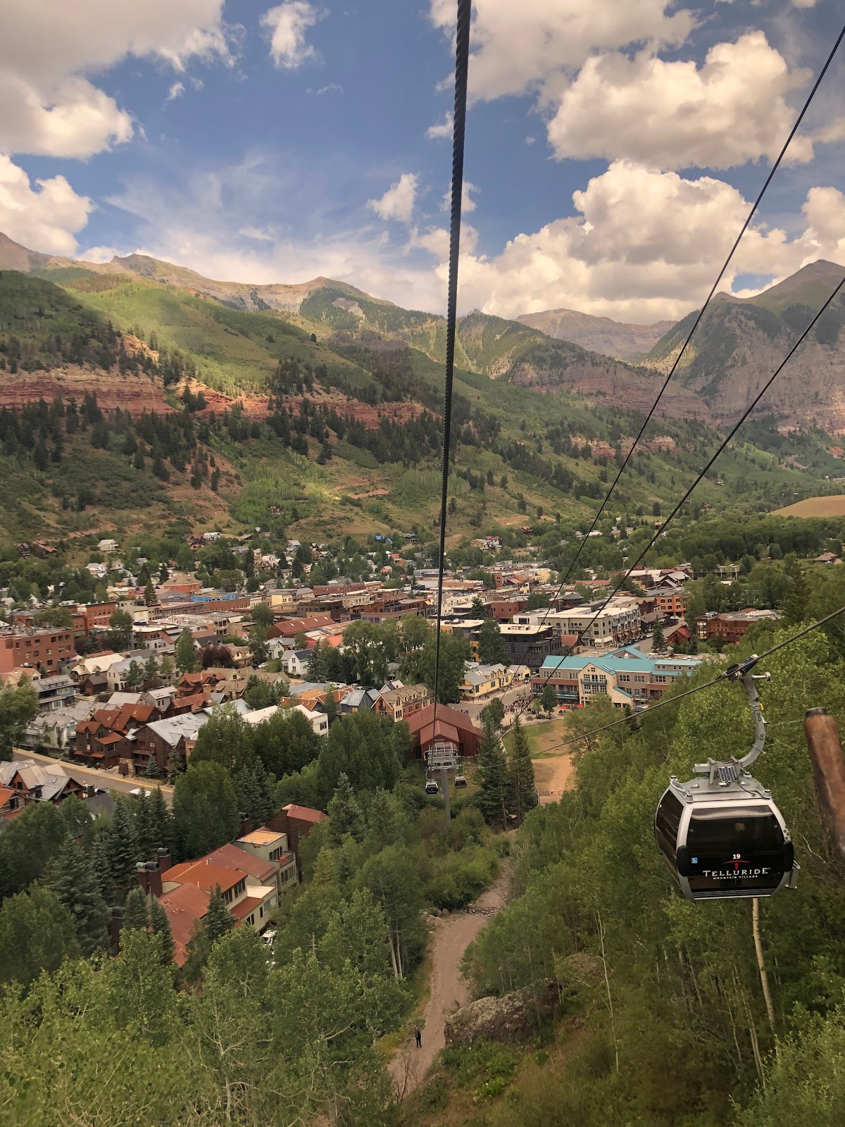
We headed into town, did a little shopping, and enjoyed hot dogs from a vendor in the park for brunch! We made reservations in the Mountain Village for an early dinner. Its easy to get there, just take the free Gondola. We wandered down and found the line nearly two blocks long.
 |
| Gondola line |
No worries, we have lots of time and the line moved at a reasonable pace.
 |
| Going up! |
Its one family to a car during COVID, which made the line move a little slower, but gave us plenty of space and privacy in the car for the 15 minute ride to the top. We arrived and made our way to the main plaza.
 |
| Mask-up! |
A band was playing some classic rock standards and we found two chairs in the shade to park and relax before dinner. Even though our reservations at The Village Table were for an outdoor table, the host insisted we sit indoors, since our reservation did not note our preference for an outdoor table. The place was nearly empty (one other table), and after we insisted, he said fine, as long as we were done in an hour and 15 minutes. I said, great, that will depend on your servers and kitchen!
It was entertaining to watch the same scenario as several other parties arrived and were seated with the same drama. The meal was fine, and we lingered for an hour and 25 minutes, just because!
 |
| Return trip |
 |
| Going down |
|
|
With the sun lower in the sky, the views seemed even better on the return trip. We wandered back through town and headed to the hotel to call it a day!
Day 4 Telluride to Cortez
 |
View from the Ophir overlook pullout
|
With grab bag breakfasts (yogurt and danish) and good coffee from an in-room Keruig machine, we enjoy a light breakfast before starting the days ride. After putting the bags in the truck, I head out to begin the ride, while Deb remains behind to enjoy a leisurely morning and giving me an ample head start! Since there is a resupply opportunity in Rico, she times her departure to meet in Delores around lunchtime.
The route repeats yesterdays ride for the first 7 miles, but no complaints, its cool and the views are great. I stop at the Ophir pullout for a photo then head back out for a 2 mile descent to the base of the next climb.
 |
Trout Lake near Lizard Head Pass
|
 |
Lizard Head Pass
|
Five miles of climbing at just under 5% and we pull into the Lizard Head Pass monument. Its a great place to take a break and enjoy a snack. Another wide pass with great views.
 |
50 miles of gentle downhill
|
Yesterday's headwind from the west was just a slight breeze today, and with the constant downhills, it was an easy 12 mile run to the old mining town of Rico
 |
Mine ruins in Rico
|
 |
Rico convenience store
|
Just under halfway to Delores, this was a good reload opportunity. Top off the bottles and enjoy a snack on the comfortable benches out front. Temperatures were in the low 70's now, but with the descent and building heat, they were forecast in the 90s in Delores and 100s in Cortez. Better get moving!
 |
Sweeping views along the Delores River
|
It was a two hour run to Delores following the Delores River. Ranches, farms, and camps filled the valley.
 |
No lunch joy in Delores
|
Right on time, Debby catches me just outside of Delores. She sprints ahead to look for a lunch spot. She ducked into a convenience store for a recommendation, the clerk said there really wasn't anything she would recommend in Delores! Already over 92 degrees, we decide to get lunch in Cortez after I finish the ride.
 |
Delores River, leaving town
|
 |
Last descent of the ride
|
The route leaves the highway and takes several county roads through farms and ranches. Before that, just under a mile of climbing at 5%, takes us out of the Delores River valley. The road is rough, but there is little traffic and with Cortez in the distance, the last 10 miles of the route go by quickly.
 |
Finish at the Cortez Hampton Inn
|
The temperature on the Garmin touched 99 degrees as I pulled into the Hampton Inn. Again, Debby was able to check-in early and get our bags in the room. We were glad we pushed straight through to Cortez. Time for a celebratory beverage and shower, while Deb hopped on TripAdvisor to look for a place to eat. She found a great dinner place, The Farm, and reading the reviews, we realized the Mesa Verde National Park was just a 30 minute drive away.
 |
Mesa Verde National Park
|
 |
Cliff ruins at Mesa Verde National Park
|
We both had the same idea, grab some fast food (Taco Bell) to eat in route to the Park, tour the park, and return to Cortez for dinner at The Farm. We rolled up to the Park with several hours before it closed and had plenty of time to check it out. It was quite hot, but most of the touring was in the truck, hopping out from time to time to check out the views and ruins.
 |
Best meal of the trip!
|
The Farm features locally sourced food, Debby enjoyed the highly recommended Yak Burger, and yours truly had a big ole Chicken Fried Steak on potatoes and sauteed zucchini. Our server was an Arizona native and made great recommendations. We had a fun table at the front window, and enjoyed the best meal of the trip!
It was a proper capstone to a fantastic trip! We hope you enjoyed riding along!