|
Crossing the Verde River on Day 2
|
Ride Report
October 2020
The Kitt Peak 600 was scheduled to go in March of 2020, but fell victim to COVID when the Kitt Peak road and observatory was closed. Also shortly thereafter, RUSA (Randonneurs USA) cancelled all events as the pandemic caused lock-downs across the country. In September, RUSA reopened events up to 300km and in October gave approval for events up to 600km.
Great news for those of us wanting to complete the full brevet series (200, 300, 400, and 600km) for 2020! Working with our regional Brevet Administrator, Mike Sturgill, we knit together a route that combined the Around the Bend 400 and a new 200 that started near 24 hour services and affordable hotels. Early drafts used the title Desert 600 and it stuck. Like the Kitt Peak series, we plan to offer routes of 100, 200, 300, 400 and 600 on October 24/25.
REGISTRATION IS OPEN AT WWW.AZBREVET.COM
Volunteers can pre-ride the course to check the route and be able to support the riders on the event day and still get credit for the event. I will be supporting the event, this is my pre-ride report.
Day 1
 |
Circle K control in Chandler at the start
|
Weather was predicted to be unseasonably hot (highs in the low 100s) so we pushed out at 4 am. Temperatures were cool and the dogs were still asleep passing through Komatke/St. Johns on the Gila River Indian Reservation. The route uses St. Johns road to avoid the heavy traffic on 51st Avenue and Laveen. Skirting the edge of town, mostly through farms and dairies (that are slowing giving way to new home developments), we find ourselves at Phoenix International Raceway.
 |
PIR at dawn
|
 |
Flag shop and museum near PIR
|
Its all quiet at the raceway and we press on westward toward and through Estrella. Back into the farm country, the route follows farm roads to the next control in Buckeye Arizona.
 |
Circle K Control in Buckeye
|
Cool temps and a pre-dawn start mean that the water bottles were finally needing a refill, so we make our first stop at the control in Buckeye, 57 miles into the ride. The route continues through main street Buckeye then back to the farms and dairies as we head toward Gila Bend.
 |
Trump country!
|
The route continues past AZ85 and takes a slightly less direct, but infinitely more enjoyable route on Old US80 to Gila Bend. We stop in Arlington and note a Trump display using an old limo!
 |
| Deer enjoying breakfast near Gillespie Dam |
 |
Gillespie Dam Bridge
|
 |
What is left of the dam in the distance!
|
A few short steep rollers and soon we are bombing down a short hill to the Gillespie Dam bridge. The Dam is in disrepair, but the scenic pullout provides a great spot to take a break and enjoy a snack.
 |
Solar farm
|
 |
| Gila River Power Station |
The next 25 miles are through farms and power stations. The road surface is excellent, and with only light local traffic. Several solar farms interrupt the agricultural farms, and soon the Gila River Power Station comes into view (reminds me of the Rebel Power Station in The Empire Strikes Back). The combined cycle (natural gas) power station is on the edge of town and is a joint venture of the Salt River Project and Tucson Electric Power.
 |
100 miles done, welcome to Gila Bend
|
The next control is the Chevron Mini Mart (formally Texaco). It had a great covered picnic area with adjacent restrooms that was perfect for a stop in years past. Alas, the curios for sale have overrun the picnic area and the restrooms were moved inside. No worries, there are better tables to the west of the store in the shade, even with some wildlife!
 |
| A Road Runner enjoys the shade too! |
 |
| Picnic area at the Gila Bend control |
Another quick snack and bottle reload and we are back on the road for the first long climb of the day. Its more of a long false flat, but with increasing grade, temperatures (over 90), and headwind, it took much longer to clear this section of the route than I expected.
(Post-ride comment: Should have grabbed an extra water bottle for the pocket here)
 |
Sonoran Desert National Monument
|
Finally clearing the pass, its another 8 miles to Mobile (School and fire/police substation). Normally we would fly by Mobile, but with the heat and headwind, I have consumed most of my water. Instead of trying to 'ration' the puddle in the bottom of my bottle for another 12 miles (about an hour), I decide to pull into the school. Its in session, the fence is open, and luckily there is a hose bib on the loading dock where I refill. (The school and fire/police substation are both fenced, if the school had been closed the fence would have prevented access to the hose bib) After a few minutes sitting in the shade of a nearby tree, its back on the road.
 |
| Full stop at Subway |
With the heat nearing 100 and still building headwind, it takes more than an hour to cover 12 miles, including another shade break just outside of Maricopa!
The heat has blown-up my stomach, so we decide to take a long break at the Subway in Maricopa. Spending 90 minutes there, it was good to reload the stomach with real food and let the core temperature drop back to normal!
Back on the road, its still 100, but with the sun a little lower in the sky, we settle into an easy digestion pace as we make our way toward Casa Grande. This is a new variation to the ATB400, going direct to Casa Grande instead of through Mansfield AZ. The first half of the run toward Casa Grande is on newer roads with reasonable shoulders. About half-way, the pavement reverts to rough two-lane highway with little or no shoulder. The lanes are wide enough and most of the motorists respect the 3 ft rule.
Its 25 miles to Casa Grande and we arrive about 90 minutes later, a reasonable pace given the conditions. A light snack and water refill at the control in Casa Grande and its onto Coolidge. The sun sets and its back to lights and reflective gear. Arriving in Coolidge in the dark, its not an official control, but a good place to stop and ice the bottles.
Its a short run to Florence from Coolidge and we decide to take another long break for dinner at the Florence McDonalds. Still suffering from a weak stomach, I figure it would be good to cool off and have a good meal for the final 50 miles to the overnight control.
D'oh; the McDonalds dining room is closed! I decide to eat at the tables outside, but it took what seemed like forever for the food to come out, and when it did, no dice. The stomach was not having it. The Drive-Thru was packed, hence the long wait, and while a McFlurry sounded good, I tossed the dinner in the garbage and headed across the street to the Speedway convenience store. A chocolate milk and ice cream sandwich did the trick and I was back in business!
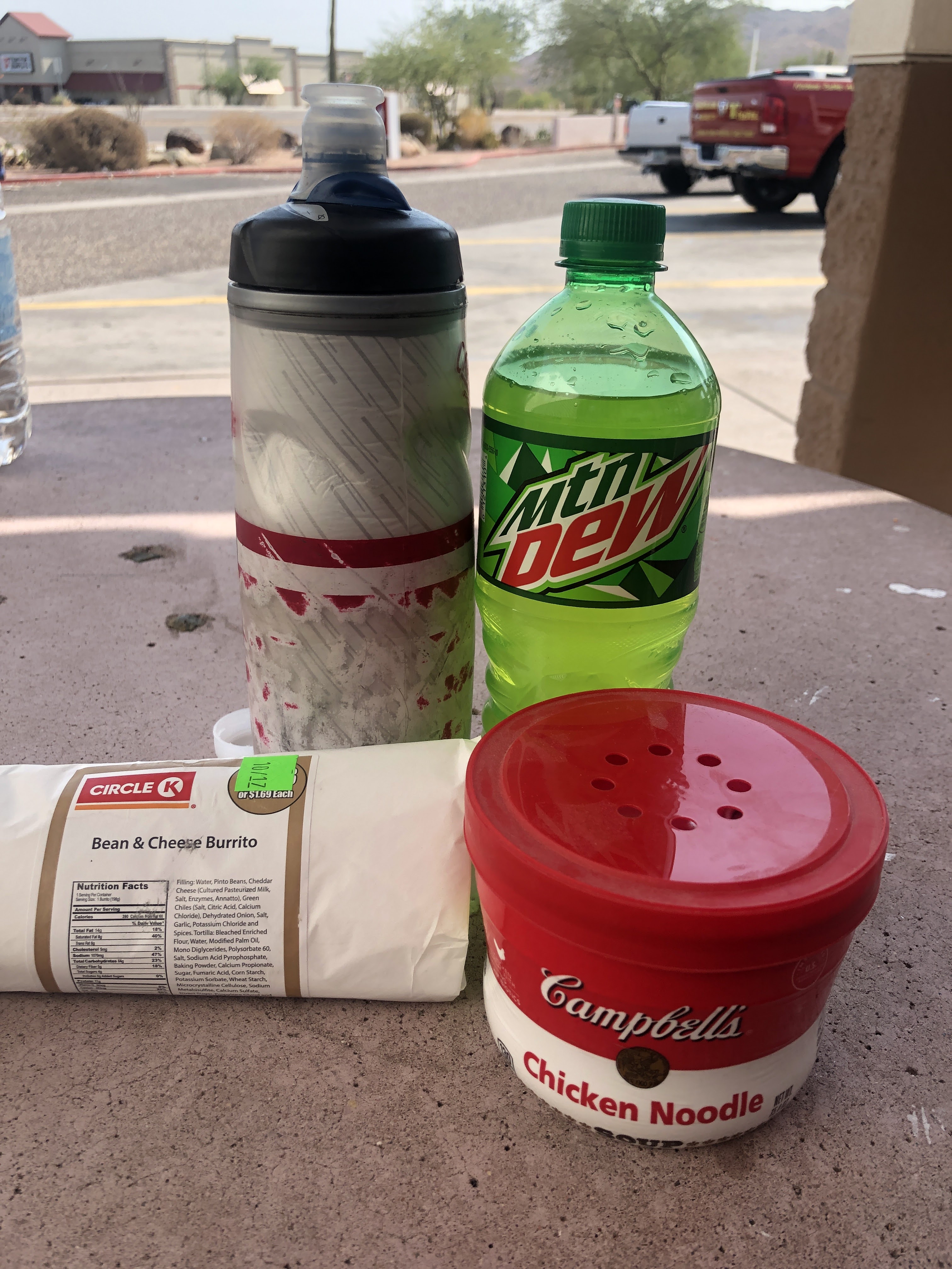
After missing the turn at Bella Vista in San Tan Valley at mile 215(making a u turn to recover), its finally onto Riggs road and one last stop before the overnight. Pulling into a Circle K, I spot some Chicken Noodle soup on the shelf and grab another chocolate milk. The sodium content of the soup is off the charts, and based on the salt stains covering my kit, I figure I need it! It works and while they were sold out of real chocolate milk, the Yoohoo 'chocolate beverage' was tasty and calorie rich!
 |
Salt and Sugar in Queen Creek
|
I rolled into the overnight control about 12:30 am. Conveniently located about a mile off-route, it was great to pull into my house for the overnight! Plugging the lights into the charger, feeding the dog, and yours truly, its time to hit the 'douches' and grab a few hours of sleep!
Day 2
 |
| Sunrise on Tempe Town Lake |
|
The alarm is set for 05:30 and I wake up at a little after 5. Reload the bike, feed the dog, and head back out for the final 200km of the ride. The route follows familiar roads (my old route to the office in Scottsdale) through Tempe and Scottsdale. Some construction to be careful of along Mill Ave, they are adding embedded light rails in the street, but soon we are on the Mill Avenue Bridge enjoying the sunrise!
 |
| Canal path in Scottsdale |
 |
| Bike route through a golf course |
The route continues over the bridge then up College/68th street to Jack Rabbit. There the route connects to a canal path and continues on bike trails up Pima toward North Scottsdale. Its a great alternative that avoids some heavy traffic areas.
 |
| Stay on Pima Path at mile 275.4! |
Only one tricky route cue at mile 275.4. Continue straight, but it looks like you should turn right, don't go under the freeway bridge! A half-mile later, a right turn leaves the path and its back on roads.
A park and Circle K at 100th Street and Thompson Peak Parkway provide a convenient reload about 30 miles into the day. The route continues north to Pima Road and then east on Dynamite toward Pinnacle Peak. There is an information control (Shell Station) at Alma School road, but the bottles are still full so its onto and down 9 mile hill to Rio Verde.
 |
The Fountain!
|
 |
Brunch at the Circle K Control
|
We enjoy the only tail-wind of the day on the run through Rio Verde and Fountain Hills. Plenty of rollers and great views make this section go by quickly. We hit the control on Shea near the Beeline Highway for brunch and a water refill.
(Post-ride comment: Should have grabbed an extra water bottle for the pocket here too!)
 |
Beeline Highway
|
The breeze is building on the nose as we head up the Beeline. Our pace slows from the heat that is starting to build and the fatigue from the accumulated miles (320 miles).
 |
Salt River at the Blue Point Bridge
|
By the time we reach the Salt River at the Blue Point Bridge, the temperature is 98+ and I seriously consider stopping and jumping in the river to cool off! Pressing on, without a swim, we turn onto Usery Pass road and start the climb. I realize there is only about a half-bottle of water left for the climb. That is manageable, but not optimal.
Just then a motorist pulls up beside me holding up a water bottle, and asks if I need anything. What an angel! I nod 'yes' and he pulls off and refills my bottles with some cold water! He and his daughter were out enjoying the river area, and said "you didn't look so good so we decided to check"!
Turns out he used to ride century events 'back in the day' and was thinking about getting back into cycling shape. I told him about our brevet and
www.azbrevet.com! I said thanks again and enjoyed the cold water on the climb! What a blessing!
 |
Usery Mountain Park Entrance
|
 |
Park Visitor Center about .3 miles off route
|
Clearing the pass, its an easy decision to stop at the Usery Mountain Park Visitor Center to take a break in the shade and refill the bottles. There is no ice, but the water fountains are refrigerated so it is nice and cold! From here its about 35 miles to the finish. Most of that will be city miles after exiting the park. Its still hot and the wind/breeze is on the nose nearly all the way in. One more stop at a Circle K at Baseline and Lindsay for water and an ice cream bar, about half-way to the finish.
I roll into the finish just before 4 p.m. to put this one in the books at 35 hours and 58 minutes!
Registration for the Desert 600, 400, 300, 200, and 100 is open until midnight October 21, 2020, go to http://www.azbrevet.com/ to check it out.
Steve Atkins
Click here for GPS Track