Ride Report
April 2021
 |
| Sunrise in North Phoenix |
The last brevet of the spring season was to be the Kitt Peak series in Tucson. Alas, the visitor center is still closed due to COVID restrictions. So Mike Sturgill dusted off the Scorpion 600km to complete the spring Arizona randonneuring series. This is a 'stinging' route with 11,700 feet of climbing from north Phoenix to Prescott and back on Day 1 and a 200k loop in Phoenix on Day 2 (only 3,300 feet). He added 200, 300, and 400 variations so there was something for everyone!
Six randonneurs would take on the 600 (Mike pre-rode it earlier in the week), one opted for the 400, and Mike and Stephen Kinney selected the 300.
 |
| Great day for ballooning |
Waking just before the alarm goes off, we make a quick cup of coffee and hop in the truck and head north to start at the Courtyard/Residence Inn hotels at 19th Avenue and Happy Valley Road. Arriving right on schedule, we unpack and head out just before sunrise under a clear blue sky.
 |
| Beautiful Sonoran Desert Drive |
Traffic is light and the route takes us north and east toward the first control in Carefree. Well, road traffic is light, but there is quite the jam of hot air balloons overhead. With only a slight breeze and little road traffic, it is easy to hear the distinctive roar of the burners igniting the propane to create and maintain lift.
The route will use the Sonoran Desert Drive outbound to Carefree and again in the opposite direction on Day 2. We don't mind, the surface is great, traffic is light and the views are spectacular. The only downside, eventually development will reach this area and replace much of it with planned communities.
 |
| Not a care in the world! |
Soon we reach the first control in Carefee. Its only 27 miles into the ride, but we decide to stop and top off the bottles so we can go 'non-stop' for the 45 miles to Wickenburg. With the delayed start, we are riding solo and can settle into a reasonable pace. Making the Carefree control in about two hours, the route turns generally west and north just as the morning wind started to build from the east and south, perfect timing.
The route continues west on AZ 74 for 30 miles, past Lake Pleasant to the US 60 just 10 miles south of Wickenburg. We make the turn and continue to enjoy favorable winds. We stop in Wickenburg for a sandwich and soda and are back on the road for the 20 mile run to Congress and the foot of the Yarnell hill. We stop again in Congress to top off a water bottle and head out for the 8 mile climb to Yarnell.
 |
| Never noticed this guy before! |
Just outside Congress, as the road tilts up, we notice a giant toad on the nearby ridge line. He is not spooked by our presence, so we creep up to take a photo! We return to the road and get started with the climbing!
We settle into a steady pace and hope the giant toad doesn't give chase! Clearing the summit we are soon descending through Yarnell toward Peeples Valley and another supply stop at the Mountainnaire Convenience store. More supplies and we push out again for the run to Prescott. As usual in Peeples Valley, the winds are strong and swirling, but mostly not on the nose.
 |
| Climb to Prescott |
 |
| Summit on the way to Prescott |
We begin the Wilhoit climb, its steeper than it appears, and finally reach the scrub pines of the forest. The road twists and turns with several short descents before reaching the summit at about 6100 feet.
 |
| Welcome to Prescott |
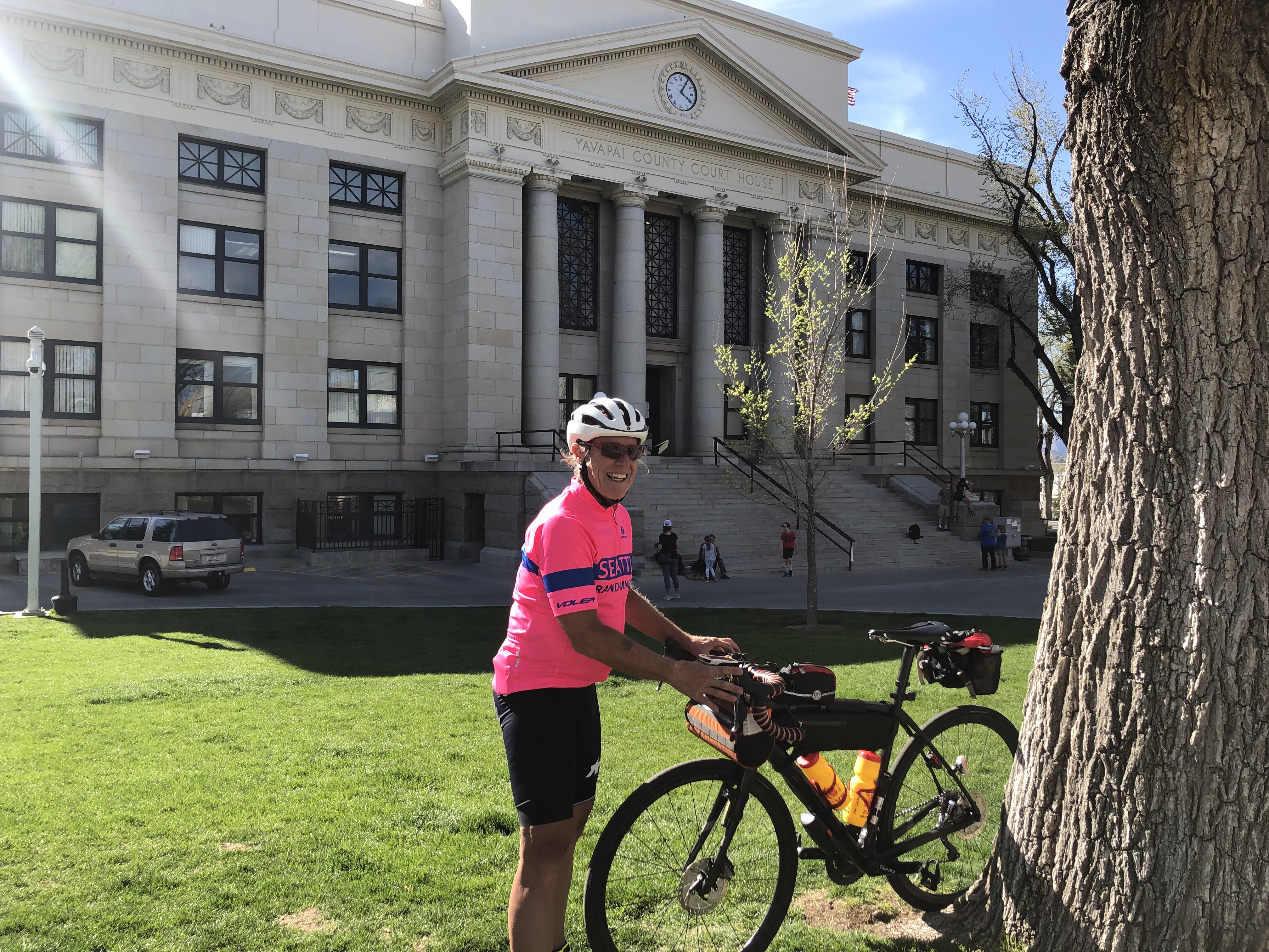 |
| Bob Fisher at the Courthouse control |
We roll onto Whiskey Row and make our way around the courthouse. Its an information control, with a question about the courthouse. Bob Fisher solved the question and Catherine Dickson and Louisa Larson were just finishing their break. We leave them at the courthouse and roll out looking for a convenience store to gather some lunch on the way out of town.
We stop at an independent quick mart and grab a soda, soup, and an ice cream! Catherine's group rolls by as we enjoy lunch. Packing up, we roll out just as Roger Peskett rolls past, heading to the courthouse to complete his loop.
 |
| Pines of Prescott |
Just a few short climbs on the way back; out of Prescott, rollers in Peeples Valley, and the short climb to Yarnell.
 |
| Roger Peskett climbing out of Prescott |
Roger catches us on the climb out of Prescott and we share the work all the way back to Phoenix. Its nice to have some company, especially at night, and motivation to keep moving. We stop at the Mountainnaire in Peeples Valley before the climb through Yarnell for some supplies. We reach the top of the hill after sunset, but with some twilight left. About halfway down we catch some traffic and slow the pace, and we happily follow behind a 5th wheel rig until the road flattens and straightens out and it rolls on ahead.
We roll through Congress and make our way to Wickenburg in full darkness. We both were in the mood for a burger, but both the McDonalds and Burger King, were closed at 8 pm! COVID strikes again!
 |
| Roger leads the way on US60 |
We continue on US 60 into Phoenix and after a few twists and turns, make our way back to Happy Valley Parkway. I tell Roger that my stomach is not right, and with 15 miles to go I tell him I am going to slow down and look for something to eat at a Circle K. Roger made his overnight arrangements 40 miles further up the road in Anthem. He stopped at a Sonic for some hot food, and I rolled on to the overnight control.
I checked into the room at 2345 and made a soup dinner with supplies packed with my overnight gear. Shower, set up for tomorrow, eat, and it was lights out at about 0100.
Day 2
 |
| More balloons at sunrise |
Waking at 0500 before the alarm (four hours of solid sleep), we start the coffee and make some breakfast. Unfortunately the instant oatmeal was inedible, but bananas, a couple of Ensure beverages, and some Pop Tarts were were enough to get me started.
 |
| Balloons drift over the road! |
We head north from the hotel to make our way toward Saddle Mountain. Its only 20 miles to the summit, but with Day 2 fatigue, and more climbing it takes about 2 hours to get there!
 |
| Several steep ramps on the way to Saddle Mountain |
 |
| Saddle Mountain (I think) |
Finally reaching the cul-de-sac at the 'summit' we roll back down the way we came. There are quite a few riders out this morning, and I catch a glimpse of Katherine and Louisa as they head up toward the 'summit.'
The route heads south and back to the Carefree Highway. Still hungry from the room breakfast fail, salvation is on the horizon.
 |
| Great brevet breakfast! |
A Burger King, with the dining room open thank you, appears on the right. We zoom in and enjoy a proper sit down brevet breakfast! Its getting warm, so we ice both bottles before pushing out and west on Carefree Highway. A good portion of the road was very recently repaved, once the lane lines get painted on it will be perfect!
 |
| I-17 Frontage Road |
The winds are building as the day goes on, and unlike our good fortune yesterday, they seem to be on the nose most of the day! We make our way back to Happy Valley road and cross the bridge for the second time on the route. Happy Valley road turns into Vistancia Blvd and we continue 2.5 miles to the next control.
 |
| Lunch! |
 |
| Catherine and Louisa roll by |
Heading back the way we came, we see Catherine and Louisa coming from the other direction, we quickly squeeze off a photo as we shout encouragement to each other!
 |
| New River Bike Path |
The route heads to the New River Bike Path and we go south. Mid-afternoon, and getting warm, we have most of the path to ourselves!
 |
| New River is barely a trickle |
The route heads south, then crosses the 'river' before climbing up the other bank and continuing north on the other side. At the crossing, there is barely a trickle of water in a small oasis of tall reeds!
 |
| John McCain Veterans Memorial Park |
Rolling along the bike path we spot what looks like a Vietnam era Huey heading into a hot LZ. Must be the heat playing tricks, its actually on a pedestal at the John McCain Veterans Memorial Park. We jump off the path to check it out.
 |
| Rest/water stop on the bike path |
The route includes just over 20 miles on the New River, Skunk Creek, and Arizona Canal Trails. Its a little slower going, but with no vehicular traffic, its much better that the surface streets in that part of town. There were several opportunities for water and rest stops which is nice. The only drawback, there are several road underpasses which were dark, and more than a few had people in them getting some relief from the heat. By the looks of the amount of trash and belongings stacked along the walls, it looks like some folks used them for sleeping too.
We took our time rolling through, and were happy that we were not rolling through in the middle of the night!
We leave the bike path at 7th Ave. and head north with about 20 miles to go. Its hot, so we make one last Circle K stop to ice the bottles and have a snack. Pushing out we head toward Deer Valley Road and make our way to the east end of the Sonoran Desert Drive off Cave Creek Road.
We decide to dial up the pace a bit to get this one done and were able to hold solid power for the last hour of riding. No balloons to be seen in the heat of the afternoon, but the Sonoran Desert Drive does not disappoint. We flash by the last information control, squeezing off a photo and putting our nose into the wind one last time for the day. |
| It is finished! |
Pulling onto North Valley Parkway, we dial the pace back to cool down over the last 4 miles and roll into the hotel control 34.5 hours after we start. Happy to have this one done, we pack up the truck and head for home.
Steve Atkins
