 |
| The End of the World! |
September 16, 2012
For years, explorers have searched the globe for The End of the World (EOW). Apparently they did not look along Arizona Highway 177 about 8 miles south of Superior Arizona! Why has its location eluded explorers for so long? Perhaps is it because of its location? The EOW is located at the very TOP of a hill with a 10 percent grade.
The EOW sits at the northern edge of an area known as the Copper Basin. Its steep slopes are known to many cyclists that have ridden the Mining County Century and is one of my favorite training areas!
 |
| KEOP (End of Pavement, Kelvin AZ) |
Its 10 miles from the EOW (3,600 ft) to the KEOP (1800 ft). With the elevation change and a few intermediate climbs mixed in, one round trip is 20 miles with about 2,200 feet of climbing (according to Mike and Carlton's Garmin GPS computers). With a number of sections of 10%+ grades it is also a great location to check out the climbing set-ups on our bikes.
 |
| Carlton and Michael at the EOW Safety Pullout |
We were surprised that the temperature was still in the sixties! Mike put on his arm warmers and soon we were descending the steep drop. Hang on, within a few seconds you find yourself speeding down the hill at 45+ mph for 2 miles on a grade of more than 10%. After a short climb, the descent continues six miles past the ASARCO Ray copper mine. We turn right on the Ray Mine Road and roll past Riverside AZ, and the Wilson Trailer Park. The road becomes rough on the approach to the single lane bridge over the Gila River. Crossing the bridge the road tilts way up 14%+ for a few hundred meters then levels off until you reach the end of the pavement. We noted a small fox on the side of the road that had an unfortunate rendezvous with a pick-up truck! We agreed later that there seemed to be an inordinate amount of road-kill this morning! On each successive lap there was less and less of our little friend, as the vultures enjoyed their morning meal!
 |
| Near the KEOP looking into the Copper Basin |
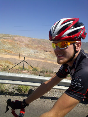
The last two miles are a very steep 10% grade with sections that reach 12%. Not as sustained as sections of the Portal Road on the Whitney, but steep enough to make sure our climbing setups are dialed in. After the first lap, Michael decided he could use the extra gears, so swapped out his road wheel with a back-up wheel with a 12-34 MTB cog installed. Mike likes to climb at a high cadence and that wheel combined with his compact crank (34/50) allowed him to really spin up the steep grades. Our plan is to start on our road setups and keep our climbing wheels in reserve for the long steep climbs of the Whitney Portal!
 | |||
| This is the last lap, right? Mike with the Ray Mine in the distance. |
Each lap took about a little less than an hour and a half, we reloaded our bottles at Carlton's van after laps 1 and 2. Our objective was to ride about 5 hours and when we reached the van on lap 3, the elapsed time on my computer was 4:55. With our time objective met, and the temperatures already over 90 degrees we decided to call it a day. We packed the bikes, toweled off and headed back into town. We decided to stop for lunch, why not continue our the day like we started, so we pulled into the Jack in the Box near Gold Canyon (not the drive through thank you!).
While we waited for our order, a mechanic driving an Empire Machinery truck, came up to us and asked if were the three cyclists he had seen earlier this morning on the climbs by the mine!
 |
| They could have easily done another lap! |
If you have joined our support team, thank you very much!!!
If you would like to support us, click here to read more about the ride or simply click here to go right to Summit Adventures Donation page (enter S.Atkins WC in the donor comment box).
Thanks!
Steve Atkins

No comments:
Post a Comment