Showing posts with label 600 km brevet. Show all posts

Monday, March 28, 2022

2022 Scorpion 600km Brevet


Sunrise at Sonora Desert Preserve

Mike Sturgill gives the rider brief

Day 1

Just under a dozen riders lined up for the unsupported Scorpion 300/400/600 events. Mike Sturgill was riding the 300, and once he completed the instructions, we all rode out together just before dawn.

James and Debbie from Green Valley
At the start of most brevets, the group is fired up and heads out like a bullet from a gun. Today I decided to start at a very easy warm-up pace and try to keep that pace all weekend. James and Debbie were using a 'slow but steady' pace also and we rode together at the back of the group.

Many balloons launching in the park.
I dropped off the pace about an hour after the start for a nature break and spotted a mass balloon launch over the shoulder! James and Debbie were caught at the light on Cave Creek and we were back together.

First control in Carefree
We reached the first control in Carefree about 2 hours after the start. James and Debbie rolled through but I stopped to fill bottles and grab some provisions. It's 45 miles to the next control in Wickenburg, and my goal was to make it there non-stop. Top off the bottle, grab a Frappuchino and some Oreo cookies, and I'm back on the road.

Rolling though Cave Creek and back to the Carefree highway, the route turns west for the 40 mile run to US 60. Traffic is heavy until we pass Lake Pleasant but thins out in the open desert. Winds that were on the nose all morning are now light and favorable as we head west and north!

Yarnell Hill Sentinel
I arrived in Wickenburg around 11am and stopped at a convenience store for a quick sandwich and a 15 minute break before heading toward Congress and the Yarnell hill. It is starting to warm up, so I stop 16 miles later in Congress to top off the bottles with ice and grab some chips and a Mountain Dew!

The Green Toad is on watch at the base of the climb, but does not appear to notice my passing, and I roll right by! Its 6 miles of steady climbing up Yarnell hill. The views are fantastic, and we reach Yarnell, but not before the temperatures hit 90!

Its a bit cooler in Peeples Valley and I stop at the Mountainaire Convenience store. Its only another 30 miles to Prescott, but those miles go over the White Spar mountains, so I grabbed a cold drink and took a break in the shade and visited with a motorcyclist who was also passing through.

White Spar Mountains
Back on the road, I enjoyed a gentle tailwind through Peeples Valley and the climb to Wilhoit. Just past the town, a few twists and turns bring you to great views of the White Spar Mountains. Today, even a little snow is still visible.

High point of the ride!
Don't be fooled by the descent, its only one of several 'intermissions' on the climb to 6100 feet outside of Prescott! Reaching the high point, its only one more roller before the 3 mile descent into town and the turn around at the Yavapai County Courthouse.

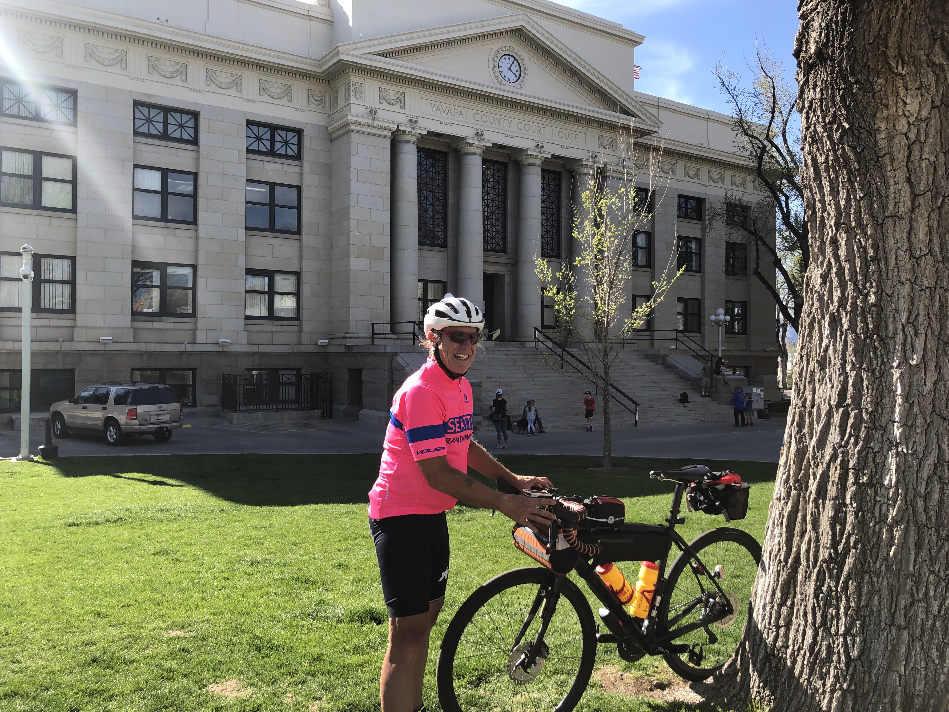
Yavapai County Courthouse
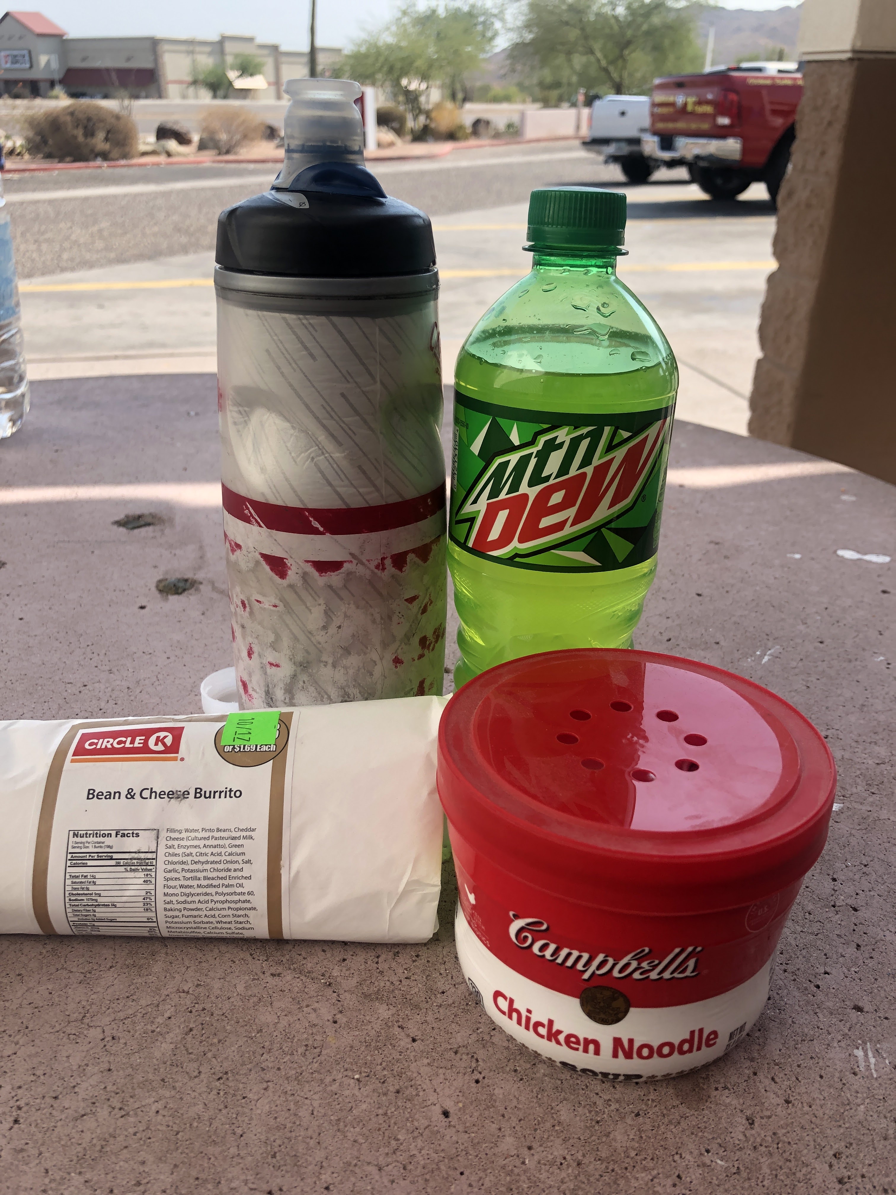
There are many places for a sit-down meal in Prescott. I opt for speed and stop at a convenience store on the way out of town for a can of Hearty Campbell soup. Feeling the salt stains all over my body and kit, I figure a sodium reload is necessary, so a V8 Juice and more chips are the 'side dish.' The sun is going down, so I finish my sidewalk meal and saddle up to head back the way I came!

Sunset on the 'Spars'

Leaving the Spars in a light show!

Back in the mountains for the return, the sunset provides new and spectacular lighting around nearly every corner! This was clearly the high point of the ride!

Peeples Valley at Sunset
With the sun fully beyond the horizon, and the air rapidly cooling, I stop to add a clothing layer at Kirkland Junction. With all the descending, we are back in Peeples Valley in no time. So with a full bottle I skip the stop at the Mountainaire store and press on through Yarnell and the descent to Congress for the next stop.

Most of this went down the hatch!
A banana and another Frappuchino in Congress held me over until the big feast in Wickenburg. Luckily, I arrived a few minutes before the McDonalds dining room closed at 10pm! After that reload, the only stop I made before the hotel was to pick up a couple of chocolate milks for the room. I checked in about 0130, cleaned up, made some soup, tossed down a chocolate milk, and was in the sack by 0230.

Day 2

Another sunrise on Sonoran Desert Drive
I woke a few minutes before the alarm went off at 0600 and cooked some oatmeal in the room microwave. Kinda rubbery, but better with some chocolate milk mixed in! Checked out, packed the drop bag and headed back out on the road at 0640.

The plan was to ride to the Circle K at Pinnacle Peak and have a hot breakfast there. Its 24 miles into the day, but more importantly, at the top of 9 mile hill. Easy downhill riding after a good breakfast is a great way to start the day.

I found a hot croissant sandwich and a large Frappuchino and settled in at the shaded picnic table for a great meal. It was delicious and in retrospect, maybe I should have gotten two sandwiches! Another rider, not on the brevet, who was visiting from New Hampshire on a rented bike joined me for breakfast.

Wildflowers near Fountain Hills
It took about 20 minutes to descend the 9 miles toward the Verde River, I was in no rush and enjoyed the easy riding. Turning toward Fountain Hills, one of the few tailwinds of the day kicked in and soon I was rolling through town. I decided to continue to Fort McDowell, about 5 miles further along the route, to make another snack/water stop.

Verde River at Ft. McDowell
The heat was on and building on the run up the Beeline Highway. I spotted another rider up the road and caught him about a mile from the top of the climb. He was not on the brevet, but seemed eager for company and we visited until the road tilted up at the Bush Highway exit ramp. It was over 90F by the time I reached top and with the wind it felt like a convection oven!

Its a nice descent to Saguaro Lake and trying to build speed for a steep roller the front wheel feels a tad mushy. A few minutes later, at the top of the roller I check the tire and its almost flat. I found a shady spot to change the tube and was soon back on the road and the building heat.

Chez Circle K, sidewalk seating in the shade please!
The last official control was in Mesa with 50 miles to go. I rolled into a Circle K for a brevet dog and some chips. I figured to make one more water stop before the finish, but ended up missing timing the stop and running low on water in the residential 'desert' of Sweetwater Ave and 56th Street between 104th Street and Bell Road!

Two Circle Ks on opposite corners were my oasis at 56th and Bell! I topped off the bottles at one, and enjoyed an ice cream at the other ( the first one's freezer was broken!) before putting the last 15 hot miles of this one in books.

Rolling into the hotel at 5:27, this one was done in 35 hours and 27 minutes!  This completes my brevet Super Randonner series for 2022, but there is still time sign up for the 'near' Kitt Peak 400 and 600 brevets on April 9. Check out Azbrevet.com for all the details!

Thanks for riding along!

Final statistics

The Scorpion 600 is in the bag!
Click here for GPS data


Thursday, April 15, 2021

2021 Scorpion 600km Brevet

Ride Report

April 2021

Sunrise in North Phoenix

The last brevet of the spring season was to be the Kitt Peak series in Tucson. Alas, the visitor center is still closed due to COVID restrictions. So Mike Sturgill dusted off the Scorpion 600km to complete the spring Arizona randonneuring series. This is a 'stinging' route with 11,700 feet of climbing from north Phoenix to Prescott and back on Day 1 and a 200k loop in Phoenix on Day 2 (only 3,300 feet). He added 200, 300, and 400 variations so there was something for everyone!

Six randonneurs would take on the 600 (Mike pre-rode it earlier in the week), one opted for the 400, and Mike and Stephen Kinney selected the 300.

Great day for ballooning
Randonneurs USA is still running events under a non-touch COVID protocol. Part of that protocol allows riders to start anytime within 1 hour of the official start time to help with social distancing. This event is scheduled to start at 5am. Let's see; 15 minutes to wake up and apply coffee, 45 minute drive to start, 15 minutes to unpack and line up, that math works out to a 0345 alarm. Yikes! I decide to start at 0600, let Mike know about my deferred start, and set the alarm for for 0445.

Waking just before the alarm goes off, we make a quick cup of coffee and hop in the truck and head north to start at the Courtyard/Residence Inn hotels at 19th Avenue and Happy Valley Road. Arriving right on schedule, we unpack and head out just before sunrise under a clear blue sky.

Beautiful Sonoran Desert Drive

Traffic is light and the route takes us north and east toward the first control in Carefree. Well, road traffic is light, but there is quite the jam of hot air balloons overhead. With only a slight breeze and little road traffic, it is easy to hear the distinctive roar of the burners igniting the propane to create and maintain lift.

The route will use the Sonoran Desert Drive outbound to Carefree and again in the opposite direction on Day 2. We don't mind, the surface is great, traffic is light and the views are spectacular. The only downside, eventually development will reach this area and replace much of it with planned communities.

Not a care in the world!

Soon we reach the first control in Carefee. Its only 27 miles into the ride, but we decide to stop and top off the bottles so we can go 'non-stop' for the 45 miles to Wickenburg. With the delayed start, we are riding solo and can settle into a reasonable pace. Making the Carefree control in about two hours, the route turns generally west and north just as the morning wind started to build from the east and south, perfect timing.

The route continues west on AZ 74 for 30 miles, past Lake Pleasant to the US 60 just 10 miles south of Wickenburg. We make the turn and continue to enjoy favorable winds. We stop in Wickenburg for a sandwich and soda and are back on the road for the 20 mile run to Congress and the foot of the Yarnell hill. We stop again in Congress to top off a water bottle and head out for the 8 mile climb to Yarnell.

Never noticed this guy before!

Just outside Congress, as the road tilts up, we notice a giant toad on the nearby ridge line. He is not spooked by our presence, so we creep up to take a photo! We return to the road and get started with the climbing!

We settle into a steady pace and hope the giant toad doesn't give chase! Clearing the summit we are soon descending through Yarnell toward Peeples Valley and another supply stop at the Mountainnaire  Convenience store. More supplies and we push out again for the run to Prescott. As usual in Peeples Valley, the winds are strong and swirling, but mostly not on the nose.

Climb to Prescott
Summit on the way to Prescott

We begin the Wilhoit climb, its steeper than it appears, and finally reach the scrub pines of the forest. The road twists and turns with several short descents before reaching the summit at about 6100 feet.

Welcome to Prescott
Bob Fisher at the Courthouse control

We roll onto Whiskey Row and make our way around the courthouse. Its an information control, with  a question about the courthouse. Bob Fisher solved the question and Catherine Dickson and Louisa Larson were just finishing their break. We leave them at the courthouse and roll out looking for a convenience store to gather some lunch on the way out of town.

We stop at an independent quick mart and grab a soda, soup, and an ice cream! Catherine's group rolls by as we enjoy lunch. Packing up, we roll out just as Roger Peskett rolls past, heading to the courthouse to complete his loop.

Pines of Prescott

Just a few short climbs on the way back; out of Prescott, rollers in Peeples Valley, and the short climb to Yarnell.

Roger Peskett climbing out of Prescott

Roger catches us on the climb out of Prescott and we share the work all the way back to Phoenix. Its nice to have some company, especially at night, and motivation to keep moving. We stop at the Mountainnaire in Peeples Valley before the climb through Yarnell for some supplies. We reach the top of the hill after sunset, but with some twilight left. About halfway down we catch some traffic and slow the pace, and we happily follow behind a 5th wheel rig until the road flattens and straightens out and it rolls on ahead.

We roll through Congress and make our way to Wickenburg in full darkness. We both were in the mood for a burger, but both the McDonalds and Burger King, were closed at 8 pm! COVID strikes again!

Roger leads the way on US60

We continue on US 60 into Phoenix and after a few twists and turns, make our way back to Happy Valley Parkway. I tell Roger that my stomach is not right, and with 15 miles to go I tell him I am going to slow down and look for something to eat at a Circle K. Roger made his overnight arrangements 40 miles further up the road in Anthem. He stopped at a Sonic for some hot food, and I rolled on to the overnight control. 

I checked into the room at 2345 and made a soup dinner with supplies packed with my overnight gear. Shower, set up for tomorrow, eat, and it was lights out at about 0100.

Day 2

More balloons at sunrise

Waking at 0500 before the alarm (four hours of solid sleep), we start the coffee and make some breakfast. Unfortunately the instant oatmeal was inedible, but bananas, a couple of Ensure beverages, and some Pop Tarts were were enough to get me started.

Balloons drift over the road!

We head north from the hotel to make our way toward Saddle Mountain. Its only 20 miles to the summit, but with Day 2 fatigue, and more climbing it takes about 2 hours to get there!

Several steep ramps on the way to Saddle Mountain
Saddle Mountain (I think)

Finally reaching the cul-de-sac at the 'summit' we roll back down the way we came. There are quite a few riders out this morning, and I catch a glimpse of Katherine and Louisa as they head up toward the 'summit.'

The route heads south and back to the Carefree Highway. Still hungry from the room breakfast fail, salvation is on the horizon.

Great brevet breakfast!

A Burger King, with the dining room open thank you, appears on the right. We zoom in and enjoy a proper sit down brevet breakfast! Its getting warm, so we ice both bottles before pushing out and west on Carefree Highway. A good portion of the road was very recently repaved, once the lane lines get painted on it will be perfect!

I-17 Frontage Road

We leave Carefree Highway and head north to Anthem. New River is the next control and the route uses the I-17 frontage road for the last 3 miles to the control. We stop in and top off a bottle before pushing out south and west toward Lake Pleasant and the next control in Peoria.

The winds are building as the day goes on, and unlike our good fortune yesterday, they seem to be on the nose most of the day! We make our way back to Happy Valley road and cross the bridge for the second time on the route. Happy Valley road turns into Vistancia Blvd and we continue 2.5 miles to the next control.

Lunch!
The solid breakfast seemed to do the trick, so we try another brevet favorite at the Circle K control for lunch. We finish the dog and Mt. Dew and about half the chips. We roll up the bag and save them for later, figuring we will need the salt.

Catherine and Louisa roll by

Heading back the way we came, we see Catherine and Louisa coming from the other direction, we quickly squeeze off a photo as we shout encouragement to each other!

New River Bike Path

The route heads to the New River Bike Path and we go south. Mid-afternoon, and getting warm, we have most of the path to ourselves!

New River is barely a trickle

The route heads south, then crosses the 'river' before climbing up the other bank and continuing north on the other side. At the crossing, there  is barely a trickle of water in a small oasis of tall reeds!

John McCain Veterans Memorial Park

Rolling along the bike path we spot what looks like a Vietnam era Huey heading into a hot LZ. Must be the heat playing tricks, its actually on a pedestal at the John McCain Veterans Memorial Park. We jump off the path to check it out.

Rest/water stop on the bike path

The route includes just over 20 miles on the New River, Skunk Creek, and Arizona Canal Trails. Its a little slower going, but with no vehicular traffic, its much better that the surface streets in that part of town. There were several opportunities for water and rest stops which is nice. The only drawback, there are several road underpasses which were dark, and more than a few had people in them getting some relief from the heat. By the looks of the amount of trash and belongings stacked along the walls, it looks like some folks used them for sleeping too.

We took our time rolling through, and were happy that we were not rolling through in the middle of the night!

We leave the bike path at 7th Ave. and head north with about 20 miles to go. Its hot, so we make one last Circle K stop to ice the bottles and have a snack. Pushing out we head toward Deer Valley Road and make our way to the east end of the Sonoran Desert Drive off Cave Creek Road.

We decide to dial up the pace a bit to get this one done and were able to hold solid power for the last hour of riding. No balloons to be seen in the heat of the afternoon, but the Sonoran Desert Drive does not disappoint. We flash by the last information control, squeezing off a photo and putting our nose into the wind one last time for the day.

It is finished!

Pulling onto North Valley Parkway, we dial the pace back to cool down over the last 4 miles and roll into the hotel control 34.5 hours after we start. Happy to have this one done, we pack up the truck and head for home.

Steve Atkins

Click here for GPS data


Tuesday, October 20, 2020

2020 Desert 600km Pre-Ride


Crossing the Verde River on Day 2

Ride Report 

October 2020

The Kitt Peak 600 was scheduled to go in March of 2020, but fell victim to COVID when the Kitt Peak road and observatory was closed. Also shortly thereafter, RUSA (Randonneurs USA) cancelled all events as the pandemic caused lock-downs across the country. In September, RUSA reopened events up to 300km and in October gave approval for events up to 600km.

Great news for those of us wanting to complete the full brevet series (200, 300, 400, and 600km) for 2020! Working with our regional Brevet Administrator, Mike Sturgill, we knit together a route that combined the Around the Bend 400 and a new 200 that started near 24 hour services and affordable hotels. Early drafts used the title Desert 600 and it stuck. Like the Kitt Peak series, we plan to offer routes of 100, 200, 300, 400 and 600 on October 24/25. 

REGISTRATION IS OPEN AT WWW.AZBREVET.COM

Volunteers can pre-ride the course to check the route and be able to support the riders on the event day and still get credit for the event.  I will be supporting the event, this is my pre-ride report.

 Day 1

Circle K control in Chandler at the start

Weather was predicted to be unseasonably hot (highs in the low 100s) so we pushed out at 4 am. Temperatures were cool and the dogs were still asleep passing through Komatke/St. Johns on the Gila River Indian Reservation. The route uses St. Johns road to avoid the heavy traffic on 51st Avenue and Laveen. Skirting the edge of town, mostly through farms and dairies (that are slowing giving way to new home developments), we find ourselves at Phoenix International Raceway.

PIR at dawn

Flag shop and museum near PIR

Its all quiet at the raceway and we press on westward toward and through Estrella. Back into the farm country, the route follows farm roads to the next control in Buckeye Arizona.

Circle K Control in Buckeye
Cool temps and a pre-dawn start mean that the water bottles were finally needing a refill, so we make our first stop at the control in Buckeye, 57 miles into the ride. The route continues through main street Buckeye then back to the farms and dairies as we head toward Gila Bend.
Trump country!
The route continues past AZ85 and takes a slightly less direct, but infinitely more enjoyable route on Old US80 to Gila Bend. We stop in Arlington and note a Trump display using an old limo!
Deer enjoying breakfast near Gillespie Dam

Gillespie Dam Bridge

What is left of the dam in the distance!
 

A few short steep rollers and soon we are bombing down a short hill to the Gillespie Dam bridge. The Dam is in disrepair, but the scenic pullout provides a great spot to take a break and enjoy a snack.

Solar farm

Gila River Power Station
The next 25 miles are through farms and power stations. The road surface is excellent, and with only light local traffic. Several solar farms interrupt the agricultural farms, and soon the Gila River Power Station comes into view (reminds me of the Rebel Power Station in The Empire Strikes Back). The combined cycle (natural gas) power station is on the edge of town and is a joint venture of the Salt River Project and Tucson Electric Power.
100 miles done, welcome to Gila Bend

The next control is the Chevron Mini Mart (formally Texaco). It had a great covered picnic area with adjacent restrooms that was perfect for a stop in years past. Alas, the curios for sale have overrun the picnic area and the restrooms were moved inside. No worries, there are better tables to the west of the store in the shade, even with some wildlife!

 A Road Runner enjoys the shade too!

Picnic area at the Gila Bend control
Another quick snack and bottle reload and we are back on the road for the first long climb of the day. Its more of a long false flat, but with increasing grade, temperatures (over 90), and headwind, it took much longer to clear this section of the route than I expected.

    (Post-ride comment: Should have grabbed an extra water bottle for the pocket here)

Sonoran Desert National Monument

Mobile Elementary School

Finally clearing the pass, its another 8 miles to Mobile (School and fire/police substation). Normally we would fly by Mobile, but with the heat and headwind, I have consumed most of my water. Instead of trying to 'ration' the puddle in the bottom of my bottle for another 12 miles (about an hour), I decide to pull into the school. Its in session, the fence is open, and luckily there is a hose bib on the loading dock where I refill. (The school and fire/police substation are both fenced, if the school had been closed the fence would have prevented access to the hose bib) After a few minutes sitting in the shade of a nearby tree, its back on the road.
Full stop at Subway
With the heat nearing 100 and still building headwind, it takes more than an hour to cover 12 miles, including another shade break just outside of Maricopa!

The heat has blown-up my stomach, so we decide to take a long break at the Subway in Maricopa. Spending 90 minutes there, it was good to reload the stomach with real food and let the core temperature drop back to normal!

Back on the road, its still 100, but with the sun a little lower in the sky, we settle into an easy  digestion pace as we make our way toward Casa Grande. This is a new variation to the ATB400, going direct to Casa Grande instead of through Mansfield AZ. The first half of the run toward Casa Grande is on newer roads with reasonable shoulders. About half-way, the pavement reverts to rough two-lane highway with little or no shoulder. The lanes are wide enough and most of the motorists respect the 3 ft rule.

Its 25 miles to Casa Grande and we arrive about 90 minutes later, a reasonable pace given the conditions. A light snack and water refill at the control in Casa Grande and its onto Coolidge. The sun sets and its back to lights and reflective gear. Arriving in Coolidge in the dark, its not an official control, but a good place to stop and ice the bottles.

Its a short run to Florence from Coolidge and we decide to take another long break for dinner at the Florence McDonalds. Still suffering from a weak stomach, I figure it would be good to cool off and have a good meal for the final 50 miles to the overnight control.

D'oh; the McDonalds dining room is closed! I decide to eat at the tables outside, but it took what seemed like forever for the food to come out, and when it did, no dice. The stomach was not having it. The Drive-Thru was packed, hence the long wait, and while a McFlurry sounded good, I tossed the dinner in the garbage and headed across the street to the Speedway convenience store. A chocolate milk and ice cream sandwich did the trick and I was back in business!

After missing the turn at Bella Vista in San Tan Valley at mile 215(making a u turn to recover), its finally onto Riggs road and one last stop before the overnight. Pulling into a Circle K, I spot some Chicken Noodle soup on the shelf and grab another chocolate milk. The sodium content of the soup is off the charts, and based on the salt stains covering my kit, I figure I need it! It works and while they were sold out of real chocolate milk, the Yoohoo 'chocolate beverage' was tasty and calorie rich!

Salt and Sugar in Queen Creek
I rolled into the overnight control about 12:30 am. Conveniently located about a mile off-route, it was great to pull into my house for the overnight! Plugging the lights into the charger, feeding the dog, and yours truly, its time to hit the 'douches' and grab a few hours of sleep!

Day 2

Sunrise on Tempe Town Lake

The alarm is set for 05:30 and I wake up at a little after 5. Reload the bike, feed the dog, and head back out for the final 200km of the ride. The route follows familiar roads (my old route to the office in Scottsdale) through Tempe and Scottsdale. Some construction to be careful of along Mill Ave, they are adding embedded light rails in the street, but soon we are on the Mill Avenue Bridge enjoying the sunrise!

Canal path in Scottsdale

Bike route through a golf course

The route continues over the bridge then up College/68th street to Jack Rabbit. There the route connects to a canal path and continues on bike trails up Pima toward North Scottsdale. Its a great alternative that avoids some heavy traffic areas.

Stay on Pima Path at mile 275.4!

Only one tricky route cue at mile 275.4. Continue straight, but it looks like you should turn right, don't go under the freeway bridge! A half-mile later, a right turn leaves the path and its back on roads.

A park and Circle K at 100th Street and Thompson Peak Parkway provide a convenient reload about 30 miles into the day. The route continues north to Pima Road and then east on Dynamite toward Pinnacle Peak. There is an information control (Shell Station) at Alma School road, but the bottles are still full so its onto and down 9 mile hill to Rio Verde.

The Fountain!
Brunch at the Circle K Control

We enjoy the only tail-wind of the day on the run through Rio Verde and Fountain Hills. Plenty of rollers and great views make this section go by quickly. We hit the control on Shea near the Beeline Highway for brunch and a water refill. 

    (Post-ride comment: Should have grabbed an extra water bottle for the pocket here too!)

Beeline Highway

The breeze is building on the nose as we head up the Beeline. Our pace slows from the heat that is starting to build and the fatigue from the accumulated miles (320 miles).

Salt River at the Blue Point Bridge

By the time we reach the Salt River at the Blue Point Bridge, the temperature is 98+ and I seriously consider stopping and jumping in the river to cool off! Pressing on, without a swim, we turn onto Usery Pass road and start the climb. I realize there is only about a half-bottle of water left for the climb. That is manageable, but not optimal.

Just then a motorist pulls up beside me holding up a water bottle, and asks if I need anything. What an angel! I nod 'yes' and he pulls off and refills my bottles with some cold water! He and his daughter were out enjoying the river area, and said "you didn't look so good so we decided to check"!

Turns out he used to ride century events 'back in the day' and was thinking about getting back into cycling shape. I told him about our brevet and www.azbrevet.com! I said thanks again and enjoyed the cold water on the climb! What a blessing!

Usery Mountain Park Entrance

Park Visitor Center about .3 miles off route
Clearing the pass, its an easy decision to stop at the Usery Mountain Park Visitor Center to take a break in the shade and refill the bottles. There is no ice, but the water fountains are refrigerated so it is nice and cold! From here its about 35 miles to the finish. Most of that will be city miles after exiting the park. Its still hot and the wind/breeze is on the nose nearly all the way in. One more stop at a Circle K at Baseline and Lindsay for water and an ice cream bar, about half-way to the finish.

I roll into the finish just before 4 p.m. to put this one in the books at 35 hours and 58 minutes!

Registration for the Desert 600, 400, 300, 200, and 100 is open until midnight October 21, 2020, go to http://www.azbrevet.com/ to check it out.


Steve Atkins

Click here for GPS Track